E-scouting just got a whole lot better with this new feature added to GOHUNT Maps


We are very excited to announce that we now have Historical Imagery on GOHUNT Maps! Historical satellite imagery is an absolute game changer when it comes to e-scouting. This is another addition to maps that we are very excited to share with everyone. Historical maps are key when you’re looking at the landscape to find places to hunt. This new tool brings you a giant library of satellite imagery for any location you want to dive into and e-scout.
No matter if you're planning an elk hunt in the mountains or whitetails in the east, there are countless ways to leverage Historical Imagery to step into the field with a better plan.
Historical Imagery is a web maps product available for our members that allows you to view previous years’ imagery. It provides hunters with a clearer picture during their e-scouting efforts of what the landscape will look like during different times of the year by toggling imagery from various seasons and years. When moving between years and seasons, a hunter can easily see the effect of wildfires, find areas with quality feed, hidden water spots, the impact of drought, snowfall, leaf-off, etc. The use cases for Historical Imagery are endless.
If you’re not familiar with GOHUNT Maps, check out the link below to learn more about everything we cover within our Insider membership to make your e-scouting, research, and hunting efforts more successful. Everything you need to have the best season ever can be found on Insider. You can also check out our maps and research tools on a 7-day free trial.
Looking back to go forward. What I’m getting at there is by using Historical Imagery, you can find hidden gems in your e-scouting efforts that will help on future hunts. In my opinion, this is another giant tool in your hunting toolkit to help plan and prepare for an upcoming hunt.
I love researching for my hunts by looking at satellite imagery across different months and years. Our new tool allows a person to hone in on the best imagery for their area and gives you the ability to see small details more easily as the seasons change.
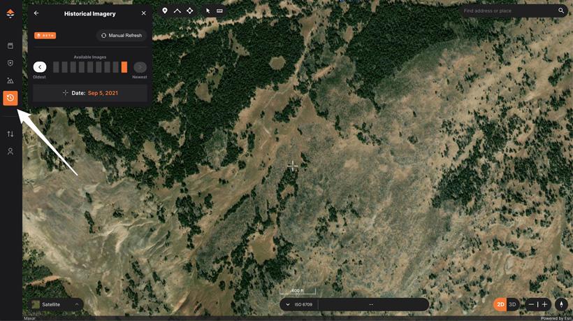
This new feature is effortless to use. To use Historical Imagery, jump over to GOHUNT Maps on the web, then click on the “Historical Imagery” button on the left toolbar (icon that looks like a clock) that can be found directly under the Terrain Analysis Tool icon.
You’ll now see a small box with the Historical Imagery tools on your screen's left side.
The available satellite images are broken up from the oldest imagery on the left and more current imagery on the right. You can click on the boxes or click on the buttons to the left or right of the "Available Images" section.
Just below that will be the capture date of the imagery, and as you click through the images, you’ll see that date will change. Note: you can also click on the map to see the imagery date. This is useful if you’re looking in an area with multiple image dates on the screen simultaneously.
Imagery dates in areas you’re looking at will depend on the location (different places will have different dates across the US).
The number of images available to you for Historical Imagery will change based on where you’re looking and at what zoom level you’re looking at. If you’re zoomed out, you’ll see fewer available historical imagery dates, then as you zoom in, more will come available to you.
Currently, our historical imagery is only available in 2D on the web version of GOHUNT Maps.
More satellite images are always better! The below images showcase what you'll be able to see using Historical Imagery on GOHUNT Maps.
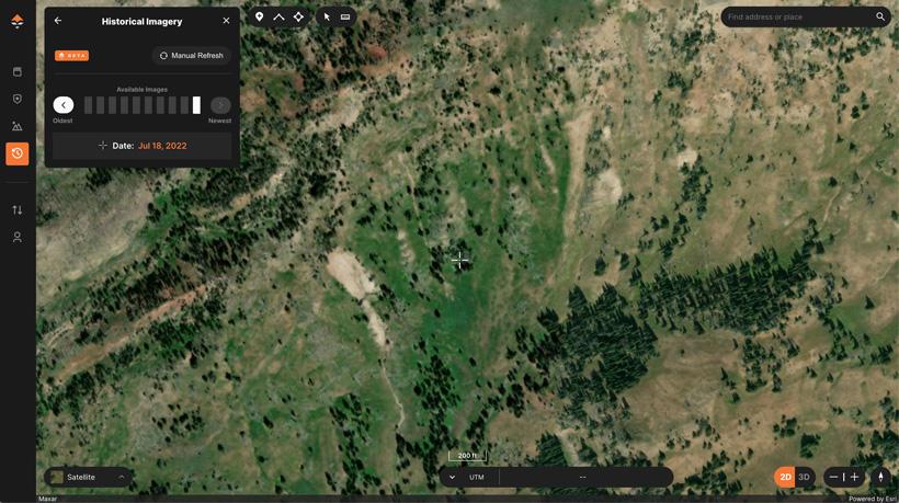
The above photo would be the most recently taken imagery for this area from July 18, 2022.
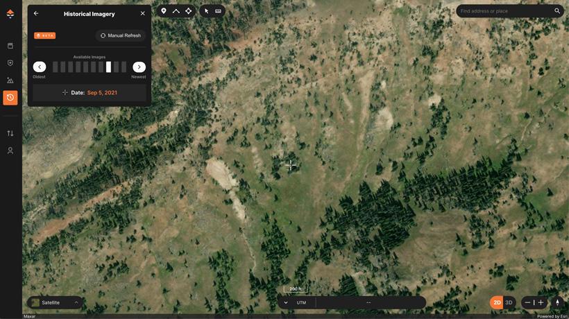
As you scroll back in time, you can now see the change in vegetation from September 5, 2021. This gives you an example of what the area might look like on a September hunt. Also, this is a great timeframe where you might be able to turn up some hidden water seeps by looking for green spots.
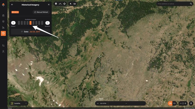
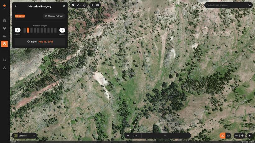
And finally, here is an image from August 16, 2011. In this case, the image actually seems a little higher quality. So while one image is great to look at, when you're able to bounce back and forth between months and years, it allows you to see subtle changes in vegetation, shadows, and even quality.
The options for how to use this tool to benefit your e-scouting efforts on GOHUNT Maps are endless! We have many articles and videos that will be released each week explaining how various team members use Historical Imagery.
A short list of ways to use this tool:
We can't wait for you to use our new Historical Imagery tool when e-scouting for your upcoming hunts. This is a game-changing feature that puts years of satellite imagery at your fingertips and can be used in combination with layers, waypoints, tracks, and other hunt-specific map content. This tool solves a lot of previous problems of trying to only e-scout with one set of satellite imagery dates, and now you have more information in front of you!
If you’re not familiar with GOHUNT, check out the link below to learn more about everything we cover to make your e-scouting and hunting efforts more successful. Everything you need to have the best season ever can be found in our Insider account. You can also check out our maps and research tools on a 7-day free trial.
Ability to see the changes to landscapes over the seasons (months) and over the years
Seeing the progression of beetle-killed areas
Analyzing timber cuts/timber aging after cuts
Tracking wildfires over multiple years
Fall leaf off
Glassing areas
Snow coverage
Analyze water in streams and rivers
Finding hidden water pockets
Wallows for elk hunting
Water holes for antelope
Locating game trails
Potential cover for animal bedding
Removing cloud cover
Drought