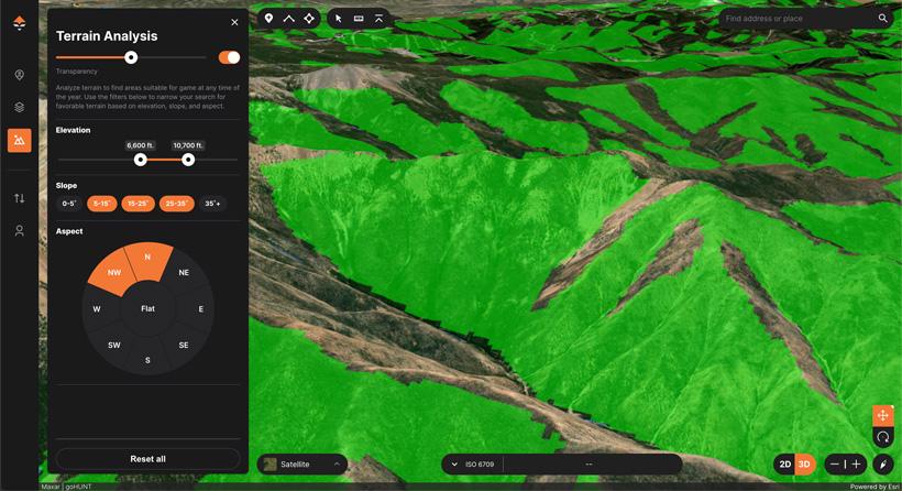


Terrain Tool showing NW & N facing slopes from 5 to 35 degrees and an elevation range of 6,600 to 10,700 feet.

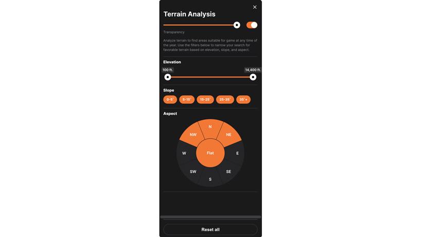
GOHUNT Maps Terrain Analysis toolbar.
Maps excite me, and today we are announcing the release of a brand new tool on GOHUNT Maps called the Terrain Analysis Tool. We love giving back to the INSIDER community and building these tools for hunters is what we are all about. The Terrain Analysis tool furthers our dedication to hunting-focused mapping innovation by allowing users to define the exact terrain features they are looking for.
This feature changes the game in e-scouting!
The Terrain Analysis Tool is a web-only mapping tool that is the perfect solution for e-scouting efforts. It’s a tool that I can honestly say I can’t live without!
The problem this solves for hunters is being able to hone in on areas where animals typically spend their day and almost equally important you can use this tool the opposite way to see areas where animals might not be! You can now find the terrain you’re looking for in seconds — no more panning the map looking for spots to e-scout.
I have a lot of specific use cases that I have been using this tool for. Stay tuned for a mule deer focused article where I take a dive into how I’ve been using this tool during application season to find new areas to research, and also finding places in units I’ve hunted before that I might want to hone in on based on in the field knowledge and data I’ve collected by dropping waypoints where I see animals and even taking data from exactly where I have taken bucks.
Allows users to define a range between 100 feet, and up to 14,000 feet. I personally use this feature a lot based on areas I have personally seen animals on hunts depending on the time of year.
The slope feature measures the steepness of the terrain you want to see.
This is broken up into:
Note: Multiple slope angles can be selected at the same time.
Allows you to select the direction you want the terrain to be facing. Again, this is very powerful when you are looking for certain locations in a unit you’re e-scouting. Animals use these different aspect ratios at different times of the year. For example, you might want to key in on south-facing slopes for shed hunting or spring bear hunting. If you’re an elk hunter, the north-facing aspect is going to be your best friend when trying to find benches and bedding areas when your bowhunting rutting bulls.
Aspect is broken up into:
Note: Multiple aspects (or all) can be selected at the same time.
This is a next-level e-scouting tool that not only saves you time but also lets you be in control of areas you want to pinpoint for your research efforts. This is the latest game-changing tool from GOHUNT and we are very excited to release this feature to our users.
If you are new to Western hunting, don’t be intimidated, INSIDER can help walk you through all the steps and GOHUNT Maps is your end to end hunting mapping solution for e-scouting and then you can take all that data and waypoints into the field through our mobile application for offline use.
Easily pinpoint north-facing slopes for elk bedding
High-country mule deer
Late-season mule deer
Spring bear spots
Finding campsites
Slope angles that typically hold animals
Ability to define your own criteria from what you experience in your scouting/hunting spot
Ability to combine with other layers to make an immersive e-scouting experience
Use this tool in 3D or in 2D
0-5°
5-15°
15-25°
25-35°
35+°
N
NE
E
SE
S
SW
W
NW
N
Flats