

When it comes to e-scouting for whitetails, it's hard to beat the appeal of crispy satellite imagery, especially when "leaf-off" images are available in your hunting areas — the imagery that was captured during winter months. We like to look for vegetation diversity and edges, but we’re not able to see the complete comprehensive picture of the forest floor. This is why you should take a look at GOHUNT's new topographical maps and discover the hidden gems in your hunt areas.
Topographical maps can sometimes be viewed as relics from another era. They're the maps that ol' gramps used back in the day, long before smartphones were ever on the market. However, thanks to new digital tech enhancements, topo maps are the first-choice view for many hunters.
What makes the GOHUNT topographical map stand out? It's not just your run-of-the-mill contour lines and shading. This topo map is a LiDAR hybrid. It's a fancy remote sensing tech that uses laser pulses to create super accurate 3D maps of the forest floor and everything in it. This is the secret sauce that gives this map its edge.
When it comes to whitetail hunting — particularly for archery hunting — tiny details matter in order to get as close as possible to where the deer are likely to travel. Terrain features play a pivotal role in shaping deer movement and bedding preferences. The GOHUNT Topo map, upon closer examination, reveals intricate topographical nuances that can significantly streamline your scouting efforts.
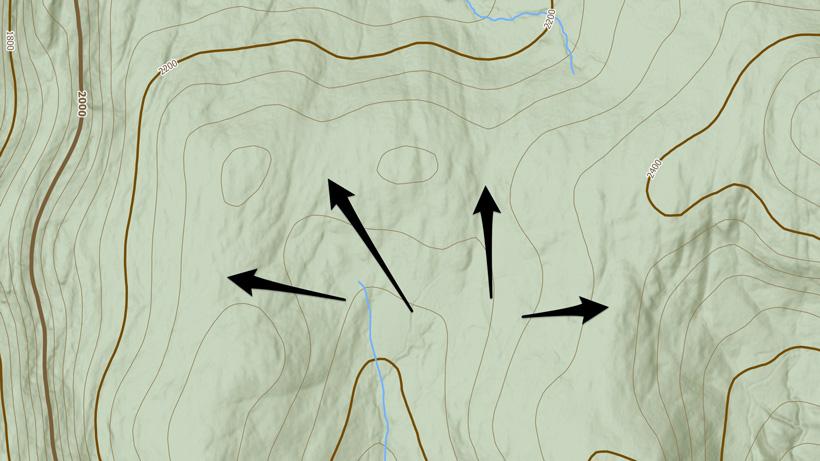
The small benches that dot the landscape on steep slopes are gems in the world of whitetail hunting. These are like the cozy recliners of the deer world. When deer bed down on these benches, they do so with a strategy in mind. They position themselves with their backs securely nestled against the mountain's slope. From this vantage point, they have an unobstructed view of their surroundings, allowing them to keep a vigilant eye out for any potential threats that might approach. This position also enables them to use the wind to their advantage. The prevailing wind direction is crucial in a deer's world. By snuggling against the mountain, they position themselves based on winds heading up the mountain or thermals floating downhill. Identifying these small benches on your GOHUNT Topo map can give you a critical advantage as to where they might be bedding in the afternoons and help predict how they might move in and out of them.
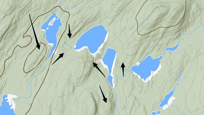
Swamps might seem like impenetrable, bewildering terrain, which is exactly why deer like to hide in them. The seasoned, big bucks are known to seek refuge in these swamps. But discovering their secretive hideouts in this dense environment can be impossible to scout. This is precisely where the GOHUNT Topo map becomes your trusted guide. It unveils the existence of small, often inconspicuous land elevations within the swamp. These are potential "bedding knobs," typically sitting just above the water level. Picture them as the isolated islands in the swamp. These knobs serve as prime real estate for bucks seeking a secure and concealed bedding location. By identifying these elusive features on the map, you gain a precious key to understanding where these wise bucks might be nestled in the swamp's labyrinthine depths.
Undoubtedly, the path to a successful hunt often hinges on your ability to approach and exit your hunting location with the utmost discretion. This is where old logging roads can come into play. They are your secret passages to quiet and swift access, especially when facing a substantial trek. Scour your GOHUNT Topo map for these logging roads as they can significantly reduce the time and effort required to reach your hunting area. And when you get the chance to walk these roads, observe how the deer themselves utilize these old logging roads. This intelligence can not only aid your access strategy but also provide valuable insights into where the deer might be moving and when.
Saddles on maps are often like magnets for hunters for a good reason. Deer are drawn to these low points in ridges and hillsides as they present an easier path for them to traverse the landscape. Similarly, "micro saddle," pinch points can be just as effective and are found within flats or subtle slopes. Look for two smaller hills or knobs on a slope and consider checking to see if the deer are traveling between the two, which, in turn, creates a natural pinch point. Sometimes, these smaller saddles are not easily identified with regular topo and contour lines. Micro saddles function similarly and can be equally effective as traditional saddles. They could potentially alter the deer's travel routes within 100, 50 and even 20 yards difference than what you might have initially thought. In whitetail hunting, where every yard is paramount this can be the difference between filling a tag and returning empty-handed.
Another great feature to look for is hillside drainages. These can be significantly deep enough that it becomes more annoying to cross for deer than it is possible. They may want to travel the path of least resistance while traversing across a slope and doing so at the top of where the drainage starts is the easiest for them. These are much easier to identify on GOHUNT’s LiDAR Topo than traditional topo maps. Additionally, look for subtle “breaks” or flatter drainage areas because those, too, could indicate where the deer get funneled for crossing.
In conclusion, GOHUNT's Topographical map is an amazing tool for finding new spots or unlocking hidden secrets in the areas you are already hunting. With GOHUNT Topo, you'll gain new knowledge and insights that could help you become a successful hunter. Start exploring GOHUNT Topo maps now and see what hidden gems you can uncover!