Cut down your e-scouting time and find where bears will be on the mountain

Bear hunting in the spring can be an action-packed way to spend a spring day in the woods. Tags are easy to get and bears can be somewhat predictable if you know where to look and what to look for. We’ve put together a few mapping tips to help you cut down your e-scouting time and find where bears will be on the mountain.
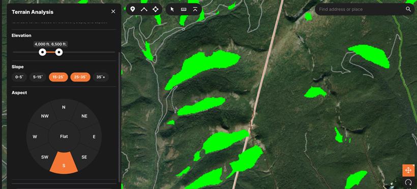
We built the Terrain Analysis Tool on GOHUNT Maps to allow hunters to input the elevation, slope and aspect they’re looking for so we can show them everywhere that meets these criteria. This is probably the most useful e-scouting tool for bear hunting because if you know what you’re looking for, this can make finding bears much easier.
In the northern hemisphere, south facing slopes are the first to melt off and green up and are often the best areas to start looking for bears. South facing slopes generally have less timber than other areas of the mountain, too, so bears can be easier to locate.
The next selection is your slope angle or the steepness of the terrain you want to highlight. While it’s possible to find bears at any point on the mountain, they’re most easily hunted on angles between 15 and 35 degrees. The reason these slope angles are important is due to the combination of vegetation, forage and visibility to the hunter. There has to be enough green grass to hunt bears while enough slope angle to see bears through the undergrowth.
The last selection on the Terrain Analysis tool is the elevation band you’d like highlighted. Hunters should use the current snowline as the upper-bound elevation and concentrate their efforts in the 500’ to 1,000’ below the snowline. If you can see a south-facing slope before heading out, use that to estimate the elevation of the snowline.
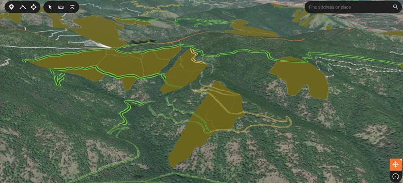
Like all animals, bears need food, water and cover to survive. Logging in a lot of western states has created prime country to find and hunt bears and usually also results in closed roads that hunters can travel up and down while glassing. The Timber Cuts layer can be enabled in the Land Usage folder of GOHUNT Maps for your state and shows areas where timber has been harvested in the last 30 years, making bears more easily visible than in mature forests. We recommend turning the transparency slider all the way to the right to highlight timber cuts and then making the layer more transparent as you look at the topography and aerial imagery of each individual cut. Overlaying timber cuts and the previously mentioned Terrain Analysis layer can pinpoint the most likely areas to find a bear on the mountain.
Pro tip: Tap on the timber cut to learn more about the acreage, year and type of timber harvest conducted in that area. If a timber cut was conducted 15 or more years ago, chances are there is significant regrowth and could be challenging to hunt.
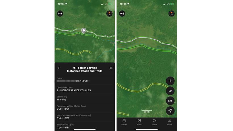
Roads are not only pivotal to planning motorized transportation to your spot, but many areas in the West will have gated logging roads that allow for easy travel by foot, horseback or bicycle into a bear hunting zone. One of the unique features about GOHUNT Maps is the road styling with green meaning it is open and yellow meaning it is in a seasonal closure. There is nothing worse than showing up to an area that you thought would be open only to find out it is closed when you get there. A proper travel plan is paramount to making sure you’re not putting in miles on foot that you didn’t account for beforehand.
Pro tip: Click on any road in GOHUNT Maps to find out the vehicle clearance level (high clearance, passenger vehicles, etc.) and open/close dates of that road.
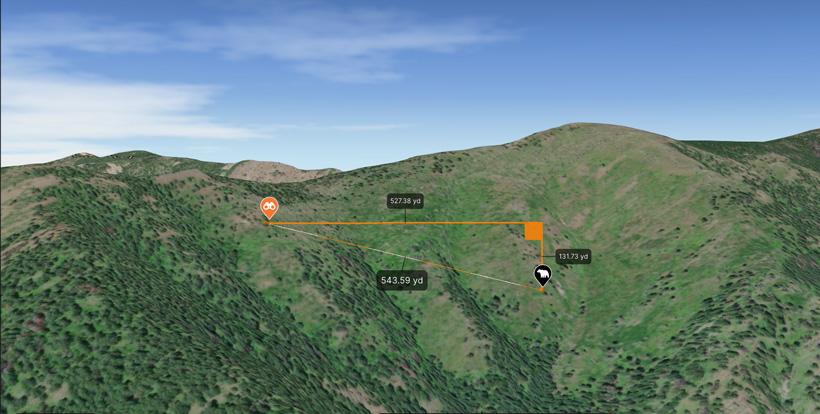
In the spots bears are generally located by hunters, often, hunters can be faced with long cross-canyon shots on bears. It is important to understand your effective range with your rifle and plan your hunt accordingly. It doesn’t do much good to get into a bear hunting area where all of the shots are beyond the range you’re comfortable with so we developed a tool to help plan areas you should be keying in on so you can get a shot off. The 3D Measurement Tool shows the line-of-sight distance, elevation gain/loss and distance as the crow flies. Using this tool in 3D mode is an incredibly useful tool when determining where your glassing points are and where you’re counting on seeing bears.
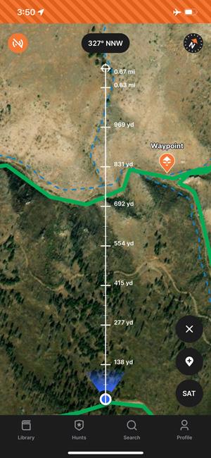
Bears are often shot in the hour before dark, making recovery tricky. Bears tend to go down in brushy areas they were feeding in and don’t have antlers sticking up to give themselves away. Mix those factors with a steep climb to the bear and the sun going down and recoveries can be difficult and sometimes dangerous. Using the GOHUNT Maps app, our rangefinder tool allows you to drop a waypoint exactly where the bear rolled to. To get started, press the “+” sign and select rangefinder. After you range the bear, simply point your phone in the direction of the bear, type in the range and hit the waypoint icon on the right hand side. This saves a waypoint in the exact direction you’re facing at the precise horizontal (not line-of-sight) distance from you. This makes zeroing in on a bear that much easier during recovery or while putting the final stalk on your target.
If you’re not a current Insider or Explorer member, now is the perfect time to join to get access to the best maps for hunters. With application season here as well, I personally use GOHUNT Maps all the time when researching what unit to apply for.