Want to find more mule deer? Want to put yourself in a spot for success? Add elevation bands to your e-scouting to crack the mule deer puzzle

Using elevation bands in 3D on GOHUNT Maps when e-scouting for mule deer.
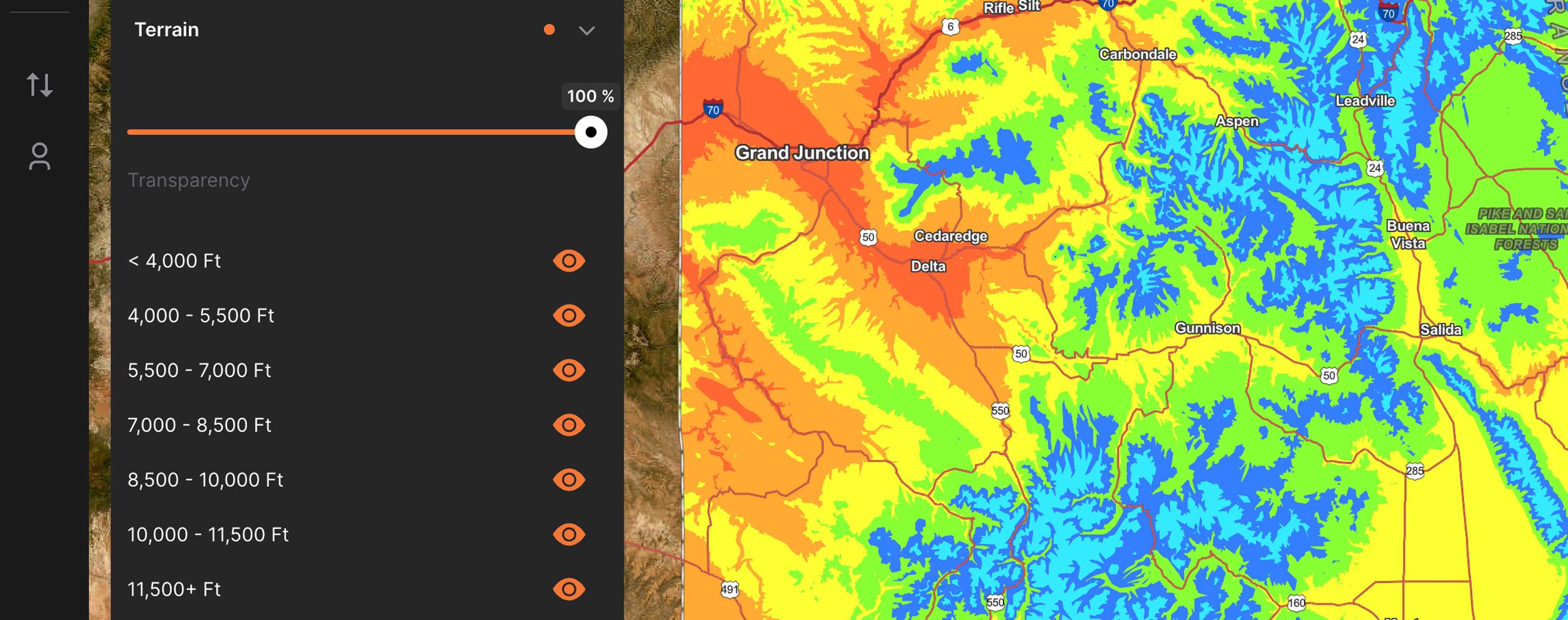
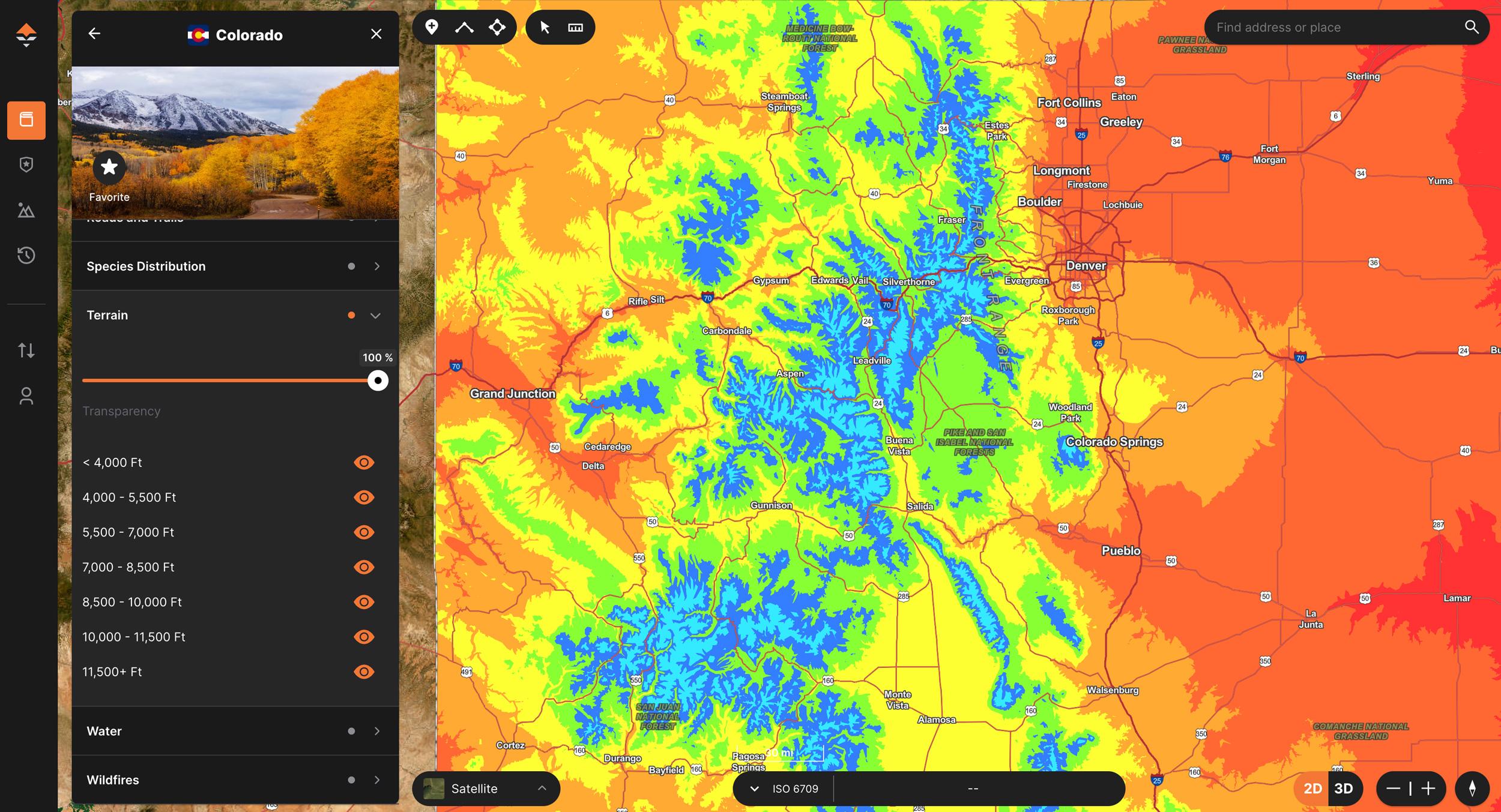
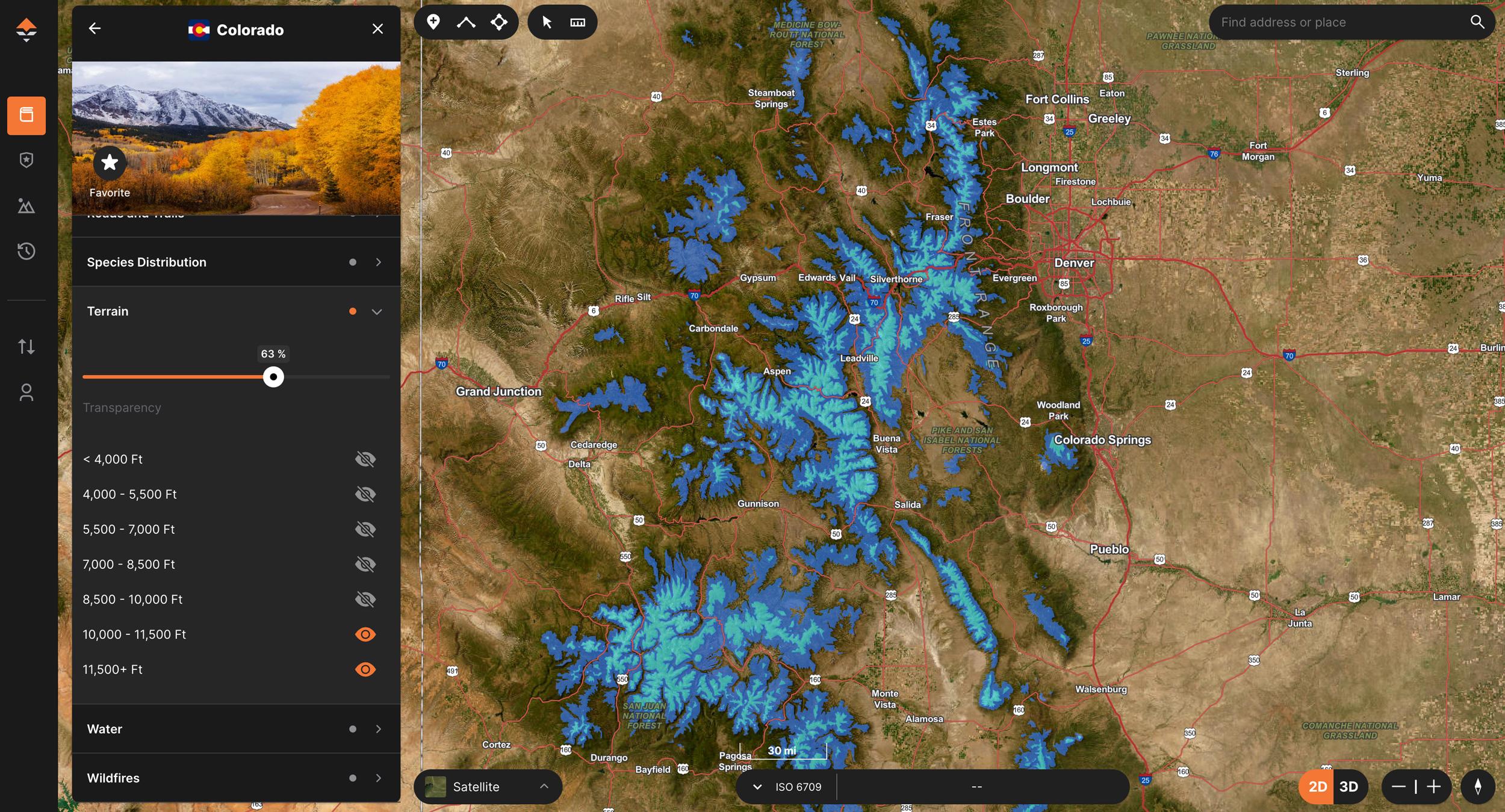
Elevation bands as a "heatmap" when looking at a state to e-scout and hunt.
It takes a few years to figure out where and what terrain types bucks tend to prefer during a specific time of theyear across the West. But you can cut your learning curve down.
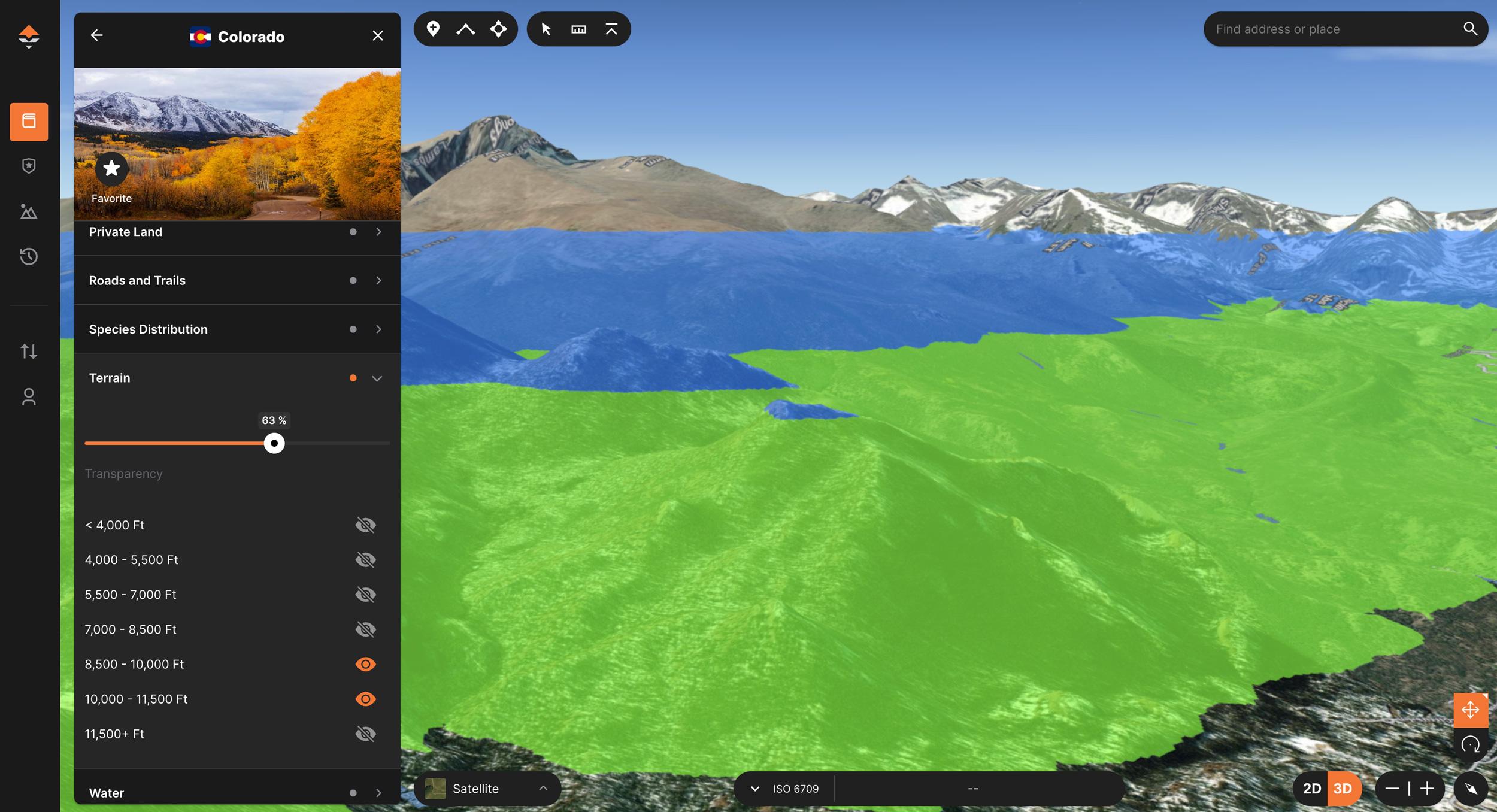
Using elevation bands to find alpine habitat for an early season archery mule deer hunt.
Zoomed-out-view-of-alpine-habitat-elevation-bands-for-mule-deer
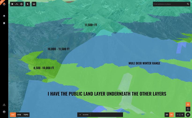
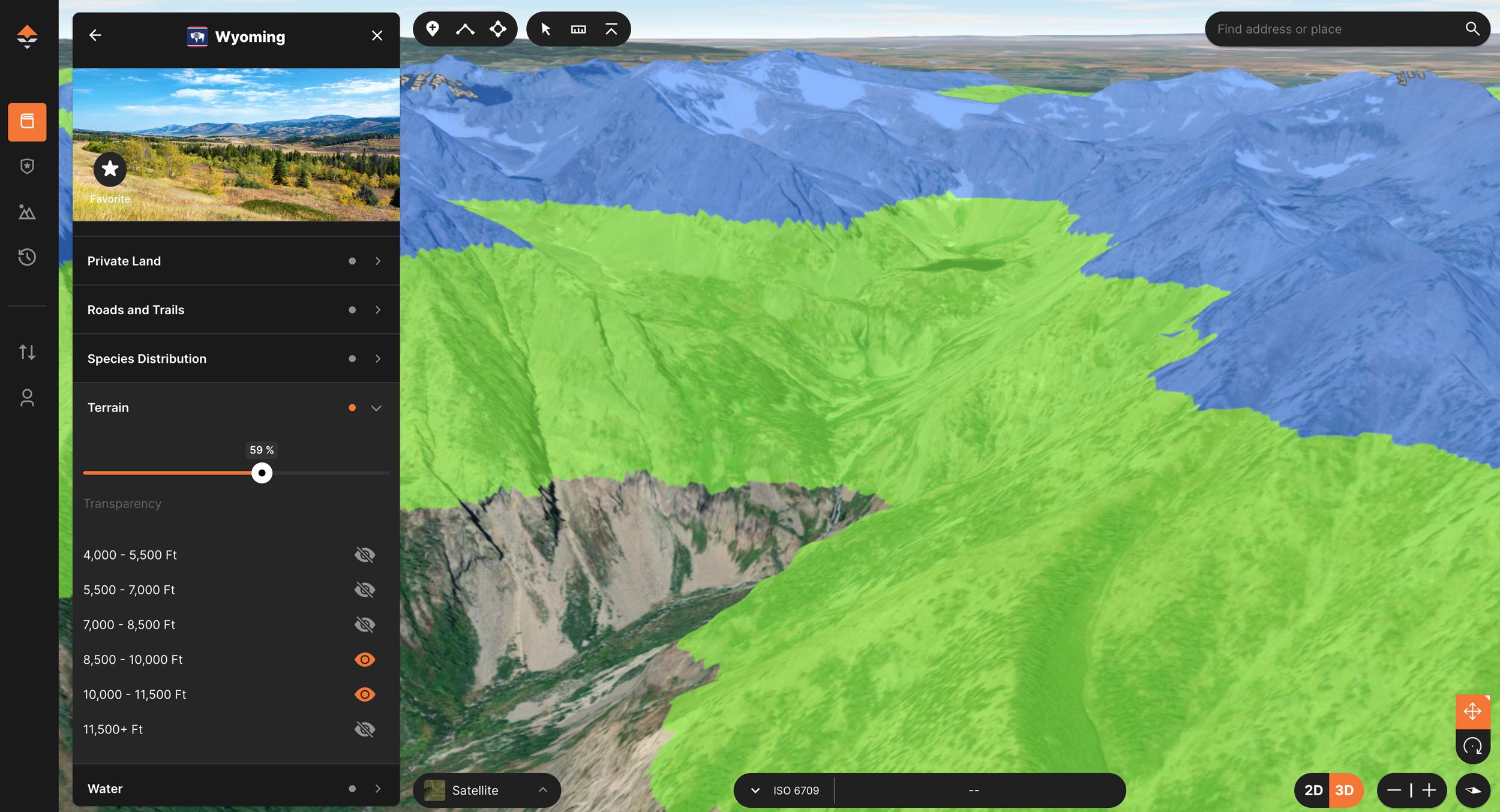
Layer stacking to showcase where I could concentrate my scouting/hunting efforts for a late-season mule deer hunt.
When it comes to planning a hunt, I’ve been employing certain strategies in my digital scouting efforts for mule deer for many years. However, I've kept some of those items to myself and haven't shared them with anyone. But as of recently, I’m excited to talk about it finally. The reason I’ve been holding back was waiting for the release of GOHUNT’s mapping application several years ago. And if you haven’t tried out GOHUNT Maps yet, it’s worth a look. You will be blown away at the level of detail and different tools and layers that are fully catered to all hunters.
With that said, the following article is going to showcase some of the ways you can use Elevation Bands on a map to aid in your mule deer scouting, research, and hunt planning efforts. As always, while I'm a mule deer hunter through and through, you can use these same techniques for other species as well.
One of the main aspects of my digital scouting, especially for mule deer hunting, is utilizing Elevation Bands to quickly narrow down an area to hunt based on the time of year I have a tag. I’m happy to say that GOHUNT has this feature in our mapping platform, available on both the web version of maps and our GOHUNT mobile app.
GOHUNT’s Elevation Bands are layers separated into 1,500 ft section bands. You can use these in a plethora of different ways by turning on one layer at a time or turning them all on to get a big-picture view (akin to a heat map) of an entire state. To turn on an Elevation Band, simply tap on the grey eye to activate it.
Below is a summary of the elevation band breakdown on GOHUNT Maps:
As you can see in the screenshot above, when you enable all elevation band layers for a state simultaneously, it essentially creates a heat map of the various 1,500 ft elevation bands. Warm colors are the lowest elevations, and cooler colors showcase all the higher elevations.
First, I should define an elevation band in my own terms.
Since I’m a mule deer hunter, my definition of an Elevation Band is “a snapshot of terrain elevation that is usable habitat during a certain core time period of a mule deer’s seasonal needs to survive.” This definition can obviously be expanded to other species as well. But this is what I believe fully describes what an Elevation Band can do and how it relates to a mule deer's annual year.
For example, if you're looking for a high country hunt, you can select the higher elevation bands and instantly see where in the unit or state those elevation bands can be found. Have a late-season mule deer hunt? You can select the elevation bands that are lower on the mountain.
If you caught the two-part series (Part 1 andPart 2) I did a few years ago on tactics for summer scouting for late fall mule deer hunting success, I broke down elevation bands and how, in time, you can put the pieces of the puzzle together when it comes to the elevation deer prefer to be at during certain times of the year. Below is an excerpt from that article:
Various types of mule deer zones:
The above zones are just a basic summary and a rough generalization. Keep in mind that where you are hunting in the West, these elevation zones could vary.
Mule deer are amazing animals. During the course of the year, you can find them in a plethora of different habitats. When it comes to mountain mule deer, it’s safe to say they live a pretty good life. From the high alpine slopes in the summer to the most picturesque color changes of early fall, snow-capped mountains during the late fall, and finally migrating across the landscape to sagebrush-filled winter ranges.
Throughout a calendar year, mule deer can be found occupying a specific elevation band, influenced by a multitude of factors. The summer months are spent gorging themselves on high alpine groceries, and in late September and the first few weeks of October, you might find them in the timber slightly below summer elevations, etc., etc.
During the fall (for the most part), bucks and does occupy a particular elevation band. They are looking for food, security away from hunter pressure, and access off the mountain if a giant snowstorm arises and they need to migrate. Using elevation bands can also help you find a little piece of the mountain that has all the needs of a big mature mule deer, and also has the security of being remote and away from places most hunters would consider.
Remember, I define an elevation band as "a snapshot of terrain elevation that is usable habitat during a certain core time period of a mule deer’s seasonal needs to survive.” Basically, that band is a snapshot in time that occupies a mule deer's essential needs.
If you're planning a high country archery mule deer hunt in August or early September, you can select the 10,000 to 11,500 ft and the 11,500+ ft elevation bands to visually see where that high country exists and what the terrain looks like in those areas. To narrow things down further, it might be a great idea to look at the areas that are at 11,500+ ft. This gives you a significant advantage when determining where to focus your research efforts.
Again, if you're in the research phase or maybe you're hunting a general tag that encompasses a bunch of units, you can use elevation bands to quickly see what unit might either have the most high country (better chance for plan A, plan B, plan C spots) or to quickly find out what units might have the perfect amount of groceries to keep those deer in the high country during your respected archery or early season muzzleloader hunt. You can also combo this with the Hunt Unit layers.
What this does is make your scouting efforts a lot faster, because from there, you can start to pick apart the terrain for possible areas where bucks will feed, where they might bed, and locate glassing spots, etc. This is also a fantastic way to see what units you might want to apply for if you're looking at an early archery deer tag next year. You can cover an entire state with the higher elevation bands, and then zoom in on the maps and carefully analyze all of the high country terrain in an easy-to-look-at format, and you're able to do this for all of the units that you have a chance to draw. So, as you can see, GOHUNT Maps and ourDraw Odds and Filtering tools greatly complement each other.
You can also utilize elevation bands to quickly narrow down potential late-season hunting areas for mule deer. Let's say you have an early November tag, and you've done your research or have some really good intel that leads to an understanding that in your particular hunting unit, bucks should start to stage around that 7,000 to 9,000 ft transitional zone. So, to visually see where you might want to concentrate your hunting efforts, you can jump over to GOHUNT Maps, select the state, and click on the Terrain Layer. Then turn on the 7,000 to 8,500 ft elevation band, and boom! You can now see all the potential areas that deer could be at during a time of year. From there, you can dive in deeper and hone in on your hunting strategy.
Another compelling feature that I would like to take a step further with is stacking other layers on top of elevation bands. This has so many benefits for not only mule deer, but also other species. Overlaying the public/private land layer and even the species distribution layer will further allow you to fine-tune your hunting, scouting, and research efforts to hone in on big buck country. All of these tools together are key to how I hunt and locate mule deer.
The best part... you can access these elevation bands on the web version and on our GOHUNT mobile app! There are definitely times I've used these layers while scouting or hunting in the field.
Check out the video below to see me walk you through the process of using these layers on the mobile app.
Elevation bands were a feature that back in the day I created for myself... and while it worked for my needs, I'm excited to see it out there for more people to use in a super simple format on our mapping platform. This was hands down my number one feature request when we originally built GOHUNT Maps. Elevation bands are way more than just elevation and lines on a map. When you take a deep dive into mule deer biology, you will see that while mule deer can be very, very unpredictable, but you can slowly add a few pieces to the puzzle and tip the scales in your direction when it comes to finding mule deer at certain times of the year.
If you’re an Insider, GOHUNT Maps is included in your membership at no additional cost.
If you aren’t a member, you can learn more here.
If you have any questions about these tactics when e-scouting for your next mule deer hunt, feel free to comment below, and I'll be happy to explain in further detail.
This article was originally published on September 24, 2020, and has been updated.
11,500+ ft
10,000 to 11,500 ft
8,500 to 10,000 ft
7,000 to 8,500 ft
5,500 to 7,000 ft
4,000 to 5,500 ft
< 4,000 ft
Summer alpine zone - 10,000 to 13,000 feet
Subalpine zone - 9,000 to 11,000 feet
Dark timber, pine, and aspen - 7,000 - 11,500 feet
Transitional zone - 6,000 to 9,000 feet
Sagebrush winter range zone 4,000 to 7,000 feet