Traffic cams, ski resort cams, Google Earth layers and other snow reports

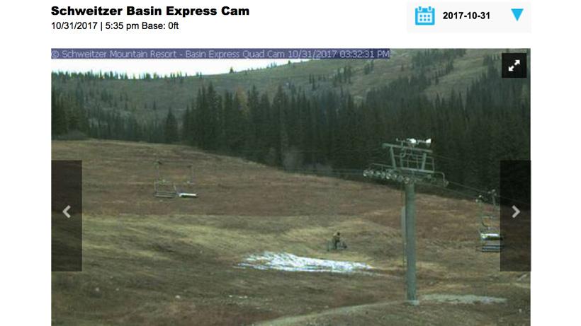
Schweitzer Basin Express webcam for analyzing snow depth.
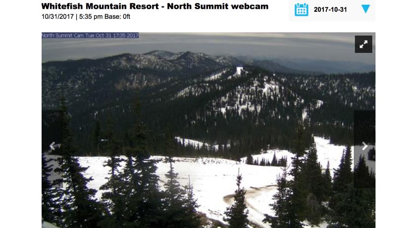
Whitefish Mountain Resort's North Summit webcam for analyzing snow depth.
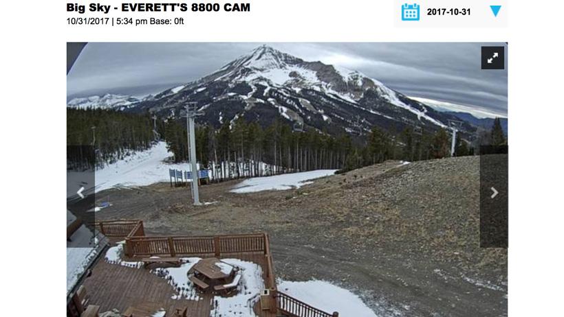
Big Sky ski resort Everett's 8,800 ft webcam for analyzing snow depth.
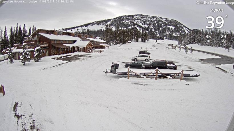
Togwotee Mountain Lodge webcam for tracking snowpack and conditions.
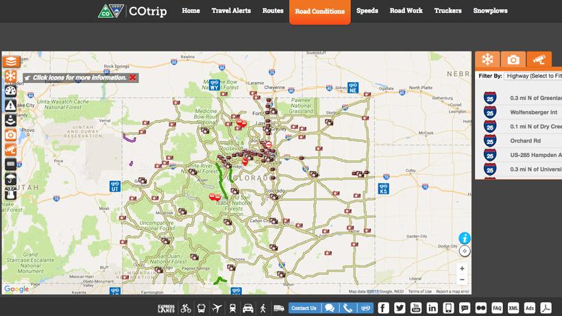
Example of what you might encounter when looking at a DOT traffic camera locations across a state.
SNOTEL snow depth sites set up to show showing inches of snow.
Google Earth layer showing winter outlook forecast.
Fall/winter conditions are definitely here across the West with blankets of snow already covering much of the high country. During these late season hunts, sometimes you need to think outside the box in order to figure out what you might expect for weather. Knowing all the weather information that is possible is pivotal to your success; knowing snowpack information could make you change your plans to a better location in the unit, or modify your plans so you’re not hunting an area that is void of animals due to migrations. After all, it’s always good to try to stay ahead of the curve when trying to figure out what Mother Nature will throw at you.
Like most of us, we might not live anywhere near the unit we’re hunting, especially when it comes to those out-of-state hunts. So, to tip the odds in your favor for what conditions you might be facing, I like to utilize an abundance of weather sources for my late season hunts. Specifically, I’m talking about traffic and ski resort webcams and also weather mapping and Google Earth layers from the National Weather Service to get a really good feel for what the conditions might be like on the mountain. Being able to gather intel from images from remote locations is a huge benefit to any scouting.
Now, yes this is using technology to your advantage, but it’s also very similar to watching the news channel or constantly checking out the daily paper.
Recently before my Colorado 2nd season mule deer hunt, I was constantly checking the weather hoping for a snowstorm and also trying to figure out what the snowpack might be looking like due to the early mountain storms earlier in October. My biggest advantage was checking out webcams and traffic cams in Colorado to see what the snowpack was looking like. On top of that, I was dissecting through the mountains of data from NOAA. And yes, I might not know exactly what the weather will be like in my unit when checking out web or traffic cams because one mountain range can be different from the next, but at least I can have a general sense of what snow conditions are looking like at certain elevations and mountain aspects.
Traffic and webcams can unlock a plethora of valuable information; what is the snowpack like at certain elevations? what aspect has melting snow? which mountain range has more snow? etc. There are plenty of ways to search for webcams. A simple Google search will turn up lots of information. But for an ease of searching, I turn to a simple ski websites for a lot of my base research.
The majority of the ski resort webcam footage that I use comes from On The Snow. What I really like about their service is it provides you will screenshots from the cams throughout the day. This is perfect for people who do all their hunting research late at night (when most cams go dark).
If you want to get even more in-depth ski resort webcams. Then your best bet will be searching for all the ski resorts in the state you’re going to hunt, then click on a ski resort's main webpage to check out if they have a webcam. Below are quick links to several western states ski resort webcams.
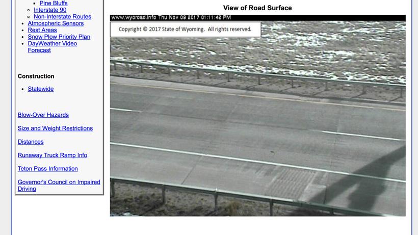
Roadside traffic cams are another great way to check out current conditions and even see some snowpack information. Another quick Google search will do wonders here for traffic cams in the state you're hunting. If you do enough searching, you can even find mountain pass road cams. Most of the roadside cameras are operated by the state's Department of Transportation (DOT) and are a wealth of information.
These roadside traffic cameras are also great for planning your driving route to see if you should leave sooner or later due to winter snow storms. Some states even show you current road surface conditions.
There are definitely other sources of traffic cameras that you can probably find. For example, NOAA does a really good job at providing links to state webcams. All of the links below utilize the states DOT webcams and are packed with useful information.
* Arizona Department of Transportation (ADOT) does make use of webcams, but the ADOT camera locations are restricted to Phoenix and Tucson areas. There is still a lot of useful information for other parts of Arizona on that page.
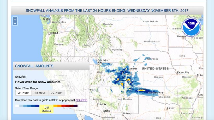
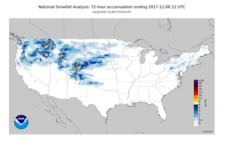
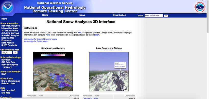
The National Weather Service also has a great tool for checking out Snowfall Analysis. You can use this for checking out recent snowfall from the past 24, 48 and 72 hours. All you need to do is hover over the area you’re looking at and it will tell you how much snow that area received.
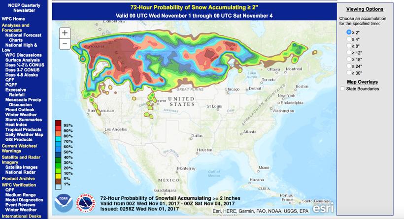
This is probably one of my favorite tools for predicting snowfall on an upcoming hunt. This tool is a beast! The Weather Prediction Center’s Probabilistic Winter Precipitation Guidance can predict snowfall and freezing rain accumulation for 24, 48 or 72-hour duration. You can also select the probabilities from 1” of snow up to 18”.
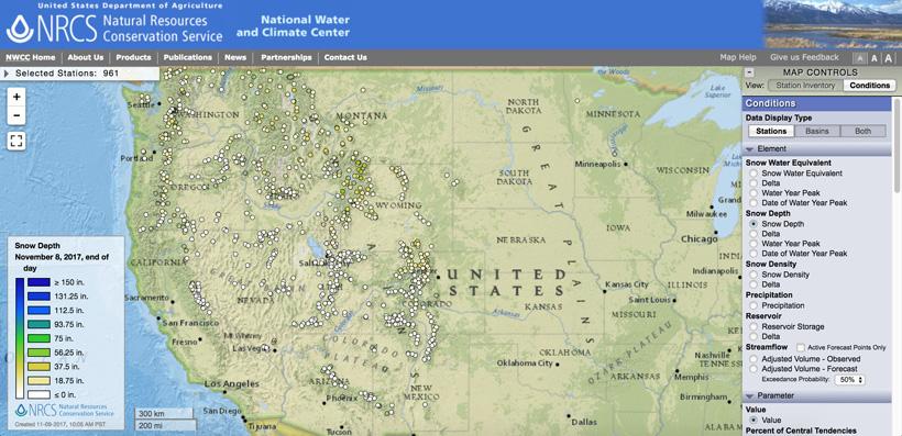
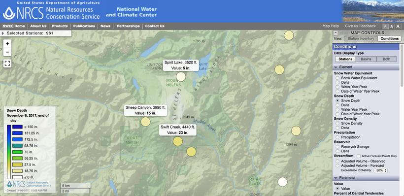
The SNOTEL (Snow Telemetry) service is fantastic for checking out mountain snow levels. I like to use their mapping product to find out the snow depth of locations in the state I’m hunting. There are lots of different tools you can use in the map controls section on the right. To use this service go here for their interactive map. Once you’re at that link, you can zoom into the state, then you are going to want to find one of the stations (the circles) that are closest to your hunting area. I like to take a look at a variety different stations at different elevations to get a feel for what the snowpack is like.
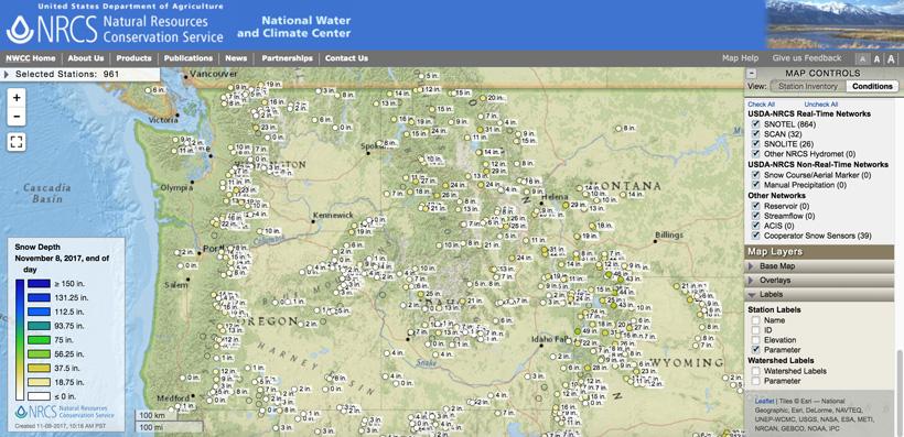
For the most part, I use Element > Snow Depth, Parameter > Value and Labels > Parameter. This enables me to get a quick look at the snow depth across the state by showing the inches at each station without having to hover over each station.
In the example above, you’ll notice that Swift Creek just south of Mount St Helens has 23 inches of snow at 4,440 ft, Sheep Canyon to the west has 15 inches at 3,990 ft and Spirit Lake has 5 inches at 3,520 ft. This is why getting a sample of the conditions near your hunting area could be very beneficial.
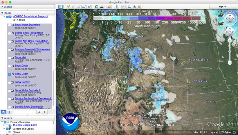
One tool I like to sync up with my Google Earth is the National Weather Service’s National Snow Analyses 3D Interface. This tool allows you to have updated snow condition information right on Google Earth.
I prefer to use the NOHRSC KML layer (under the Snow Analyses Overlays) as this provides a great way to visually see the snowpack across an entire state. Also, this layer has several different sections to it: Snow Water Equivalent, Scaled Snow Precipitation, Scaled Non-Snow Precipitation, Average Snowpack Temperature, Snow Melt, Snow Cover, Snow Depth, Snow Density, Snow Water Equivalent, Surface Sublimation/Condensation and Blowing Snow Sublimation. You can turn these sublayers on and off depending on what you're interested in looking at.
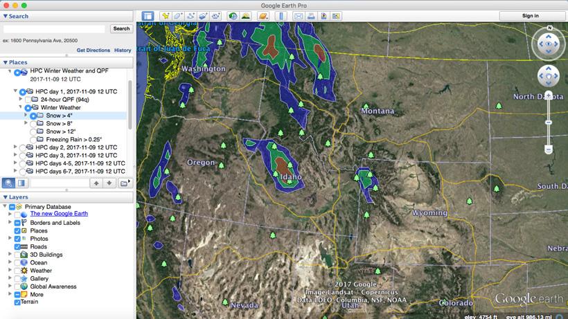
Another feature that is great if you want to run everything off of Google Earth is utilizing NOAA's Winter Outlook Snow Probability Forecasts in 3D. This will again allow you to download a KML file that will show you the one day, two-day, three-day, four to five day and six to seven-day snow level predictions.
As you now might know, I'm pretty obsessed with weather and data when planning my hunts. These tools I find invaluable for determining where I might hunt the few days leading up to my trip. Hope this helps on your next late season hunt!
|