The power of 3D is you can use it on any terrain. Even terrain that is slightly rolling you will benefit from a full 3D view.
It doesn’t matter what animal you are hunting or where you live: e-scouting can help you bring your hunting to the next level and become more successful while investing fewer days in the mountains. A few years ago, GOHUNT released another excellent add-on to the membership: a mapping feature. Plus, they added a maps only membership called Explorer for those people who just need maps. Insider members still have GOHUNT Maps as part of the membership included with all the research tools at no extra cost. Determining odds, finding units and scouting using 2D and 3D maps tailored for hunters all on one website is a real game-changer. To be 100% honest, at first, I was skeptical because I have used other mapping programs for years; however, after a few days of playing around with the maps, I understood why GOHUNT Maps are going to be my new go-to mapping platform. Why? Because it was made 100% for hunters.
Here are some tips, tricks and examples that I have figured out, which have me loving GOHUNT Maps. I use these maps to scout and then take their mobile app offline for all of my hunts.
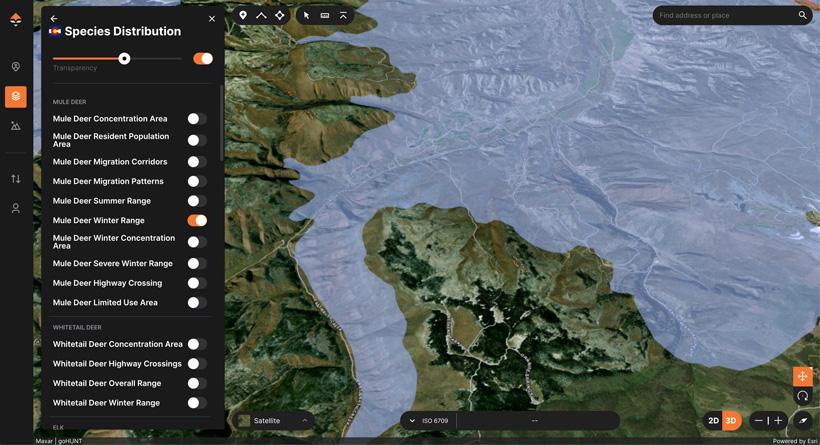
Like everything GOHUNT does, they cater to hunters and help those hunters obtain success. The first thing I love about GOHUNT Maps is that it has all of the layers made for hunters. I can go to Colorado and turn on migration corridors or wintering and summering grounds. Go to Wyoming and look at wilderness areas that will require a guide or go to another state and look at elevation bands. Colorado migration corridors, winter and summer range data per species give me an excellent starting point for my scouting. If it’s archery season, I might concentrate on the summer layer, but as the seasons progress, I look at the migration corridors and the wintering grounds to plan my hunt. Wyoming has an interesting state rule that says nonresident hunters cannot hunt in a wilderness area without a guide or a resident companion. This can damper a hunter’s public land options on a unit with a high amount of wilderness area. When scouting and using GOHUNT Maps, I can turn on layers such as wilderness areas, change the transparency and see where I can hunt if I draw that unit and use this information to decide if it is worth it. The last tip I started using this year is elevation bands. During the preseason, I will determine what elevations deer usually are at in some of my spots, then move that through some new areas to find similar elevations. During shed season, I locate what elevation I find my first shed in and then find other places at that elevation since I can typically find sheds at similar elevations. Overall, there are more layers than this, but these three are the favorites that I have been playing with recently.
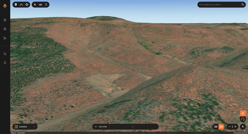
By far, the most remarkable thing about GOHUNT Maps is the 3D version of the maps. For years, I have been using Google Earth for 3D and then other companies for 2D maps. This has been a pain to download the Google Earth file and upload it on my hunting maps; however, those times are over. The first benefit of 3D is to give you an accurate picture of what the basin looks like as if you were standing in it. This can help you get a precise idea of what the unit looks like and help you understand that hiking to that ridge or peak might not be as easy as it seems while you were looking at a topographic map. The second reason 3D is a game-changer is that it allows you to rotate the map and see what you will see from a chosen glassing point. I use this benefit every time I pick a new spot to glass from. It quickly allows me to decide if that is worth hiking to, especially if I plan on glassing for the day. The final benefit has to do with the measuring tool and the information it displays. The measuring tool gives you straight line distance and actual distance, which can help you decide if you can shoot across the basin or if you will have to pick a different shooting point. I will be using this on my spring bear hunts to see if I will be able to shoot into some avalanche chutes on the opposite side of the basin. The 3D maps are a fantastic tool to use when e-scouting.
The third benefit of GOHUNT Maps that is awesome for a western hunter is choosing the color and icon of the pins you drop and organizing your pins in collections. This means that I can separate my pins by species, by states or, even, by years. Their Hunt folder will allow me to turn on Colorado archery pins and quickly see a plan. Then I can create another folder called "Colorado rifle pins" and show pins I have saved for rifle hunts. It will take a little bit of time to get all your current points organized; however, I promise you will be way more prepared for years to come when you are done.
It doesn’t matter whether you are hunting deer, elk, bear or any other western species; e-scouting is crucial to making your limited days in the mountains more effective. Using the GOHUNT Maps to help you is something you should consider. Not only is it built for hunters with the tools you need to find honey holes, but the price is also perfect — it is already included with your Insider membership or you can purchase their new maps only membership Explorer. Unlike other mapping companies, GOHUNT allows you to see all states without upgrading your plan. I plan to use GOHUNT Maps again this fall for my hunts you should also use it; it is a real game-changer.
This article was originally published May 3, 2022.