


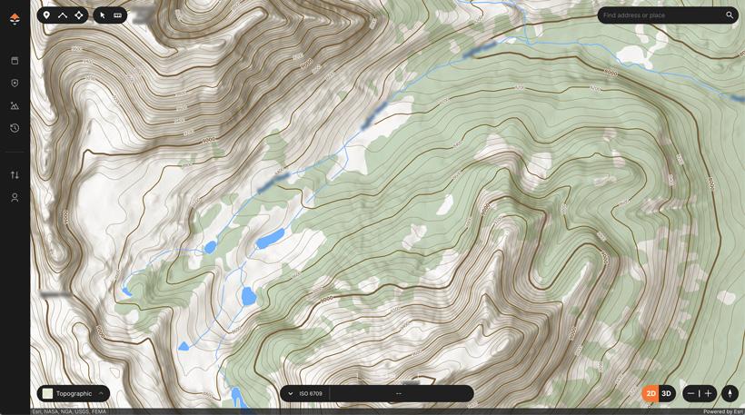
Screenshot of GOHUNT's topographical map.
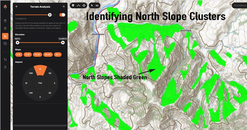
Screenshot showing the power of GOHUNT's Terrain Analysis Tool for finding north-facing clusters.
Reading and interpreting topographic maps is not merely a technical skill; it's more of an art that all elk hunters should embrace. These detailed and sometimes intricate maps offer a window into the western landscapes and can help you identify specific elk-finding features.
Elk hunters who possess the ability to decipher the contour lines, intervals, symbols, and features have a significant advantage. Topographic maps provide a three-dimensional view of the terrain on a two-dimensional surface, enabling elk hunters to visualize elevation changes and identify preferred elk habitat features.
In this article, we will unravel a few of the key topographic map reading principles needed to enhance your ability to effectively navigate in the backcountry and ultimately increase your chances of finding more elk.
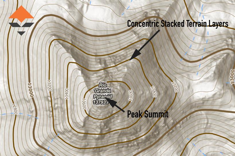
Contour lines are the visual code foundation when it comes to reading and interpreting topographic maps. Contour lines represent stacked "layers" of the terrain's elevation. A peak will appear as a dense group of lines with a central circle indicating the summit. These concentric terrain circles offer a top-down landscape view, showing height and shape. Evaluating the contour interval is crucial as the scale can vary widely from one map to another.
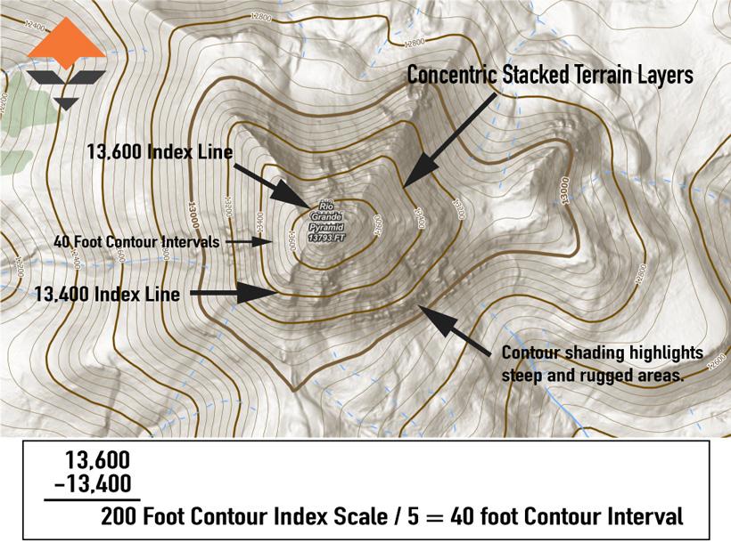
The contour index lines on a topographic map are the bolded contour lines, typically labeled with the elevation value they represent. These bold lines occur every fifth contour line and provide reference points for determining the elevation of specific features on the map. The contour index lines make it easier to read and interpret the map by indicating the elevation at regularly defined intervals.
The contour interval, on the other hand, is the vertical distance between adjacent contour lines on a topographic map. It represents the change in elevation from one contour line to the next. The contour interval is crucial for understanding the steepness or slope of the terrain in a particular area.
For instance, if the contour interval is 40’, it means that the elevation increases or decreases by 40’ between each contour line on the map. If the contour lines are closely spaced, it indicates steep terrain, while widely spaced contour lines suggest flatter, more gentle terrain.
TIP: The GOHUNT Map topography basemap has undergone an upgrade and they even created their own proprietary topography map. The upgraded topography maps now offer enhanced contour shading. This shading effect gives a 3D look and feel, which is incredibly helpful when it comes to interpreting and evaluating the overall steepness of the terrain.
In the example below, the contour index elevations are labeled as 13,600’ and 13,400’. This means that this map is representing a 200’ index scale. There are five individual contour lines between each bold contour index. The next step is to divide the index scale by five. Once you do the math, you find out that the contour line interval on this map is 40’. This is a common scale for many western state maps. Misinterpreting the index scale can lead to great difficulty when it comes to visualizing the topography and navigation. For example, a 400’ index scale map might give you the initial impression that the terrain will be easy to navigate when, in reality, it might be incredibly difficult or, even, impossible.
Now that we understand how to interpret contour indexes and intervals, we can move on to identifying specific topographic features to find elk. Certain topographic features are particularly attractive to elk, and learning how to identify and link them together can significantly increase your chances of success.
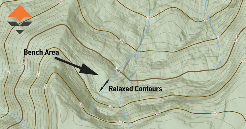
A bench on a topographic map appears as a shelf-like formation on the landscape. Benches are characterized by a relatively flat or more gentle sloping area that is situated between steeper sections of the vertical terrain. Bench features serve as preferred habitats for elk, offering a diverse range of benefits that make them extremely attractive. Bench areas act as crucial transition zones between steeper, higher elevations and lower-lying areas.
This is also another use case for GOHUNT's Terrain Analysis Tool.
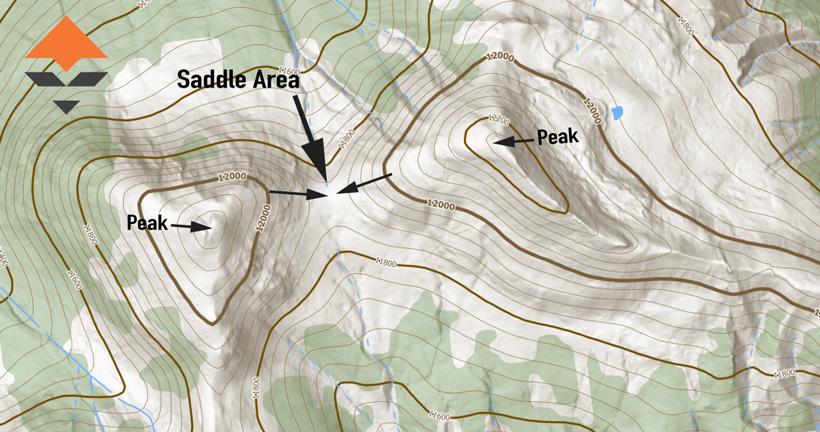
Saddles in the context of topography maps refer to low points or passes between two higher elevations, resembling the shape of a horse's saddle or figure eight. Identifying saddles on a topographic map can provide valuable insights into potential travel corridors and funnel spots.
On saddles, the contour lines will form a "U" or "V" shape on the map. These contour lines should show a descent down from both high sides, meeting at a central low point.
Drainages are another essential elk-finding feature. All drainages are not created equal, and having the ability to identify the more optimal drainages can provide key insights into elk behavior and movement patterns.
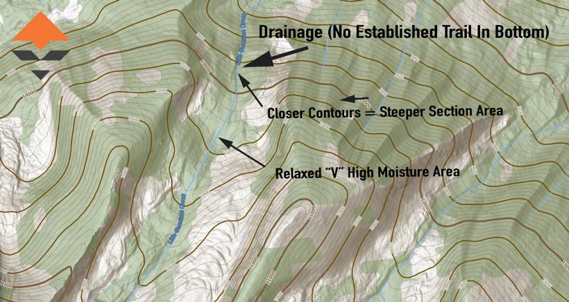
You can identify drainages by the “V” shape contour lines converging into a point. The sharper the V, the more rugged the drainage can be. These contour lines indicate the path of water flow down the slope or mountain. The steepness or fall of the drainage slope will determine the moisture levels in the drainage.
Drainages with more relaxed topography sections, as shown in the image below, can hold more moisture, which can translate into more feed and vegetation growth. Once you find a drainage that meets this criterion, switch to the aerial image view and look for tell-tale green patches or sections along the drainage bottoms.
Slope orientation refers to the direction in which a slope faces, whether it is north-facing, south-facing, east-facing or west-facing. Understanding how elk interact with different slopes can be incredibly valuable. Personally, I spend a lot of time evaluating slope orientation and I cover this process in detail in my OutdoorClass course “Next Level E-Scouting” and in my Treeline Academy “E-Scouting Elk Course.”
The GOHUNT Maps Terrain Analysis feature is a fantastic tool that will help you to isolate and identify slope orientation. During August, September, and even early October archery elk hunts, I like to find areas with high concentrations or clusters of northerly-facing slopes. These can be prime elk-holding zones.
Ridge lines are the elevated crests or tops of hills and mountains. These topographic features can play a significant role in shaping elk behavior and movement patterns.
The contour lines on the ridgeline will be convex — bulging outward — indicating the descent on both sides of the ridge. The distance between the contour lines will be on each side, indicating the steepness of the terrain along the ridge.
On either side of the ridgeline, the contour lines will form "V" shapes pointing downhill, representing the adjacent drainages or slopes. The ridgeline acts as a natural divider between drainages.
Mastering the art of reading topographic maps is crucial for elk hunters as it enables you to locate preferred elk habitats, understand and evaluate the terrain difficulty as well as plan out efficient navigational routes.
By understanding contour lines, intervals, and specific elk-finding topographic features, hunters can elevate their e-scouting, hunt planning, and backcountry tactics. This combination will directly translate to more success.
In this article, we only scratched the surface. If you want to learn more about using topographic maps to isolate elk-finding features, you may want to consider the following additional resources:
Feeding sanctuaries: Elk frequent bench areas because the relaxed terrain can hold more moisture, directly translating to better and more abundant vegetation.
Bedding zones: The relatively flat terrain of benches offers elk desirable spots to bed throughout the day, allowing them to conserve energy during periods of inactivity.
Rutting activity: During the rut, benches become critical zones for the elk rutting process.
Historical use: Elk often return to certain bench features year after year during the rutting periods. Observing both fresh and older rubs on the same bench area might be a telltale sign that you've stumbled upon one of these historical use locations. Identifying these spots can prove to be valuable. These are prime spots to keep on your hit list year after year.
Ambush opportunities: Saddles can be great ambush points to intercept elk as they pass through these natural corridors.
Migration: During migration periods, saddles become critical funnel points for elk movement. Positioning yourself at these locations at the right time of the season can prove rewarding.
Linking habitats: Elk can use saddles to connect different habitats like basins, feeding areas, and bedding grounds. Elk often utilize saddles to move between resources and security areas.
Safety: Saddles can be strategic spots in areas with high predator or hunting pressure.
Behavior: North-facing slopes receive less direct sunlight, resulting in cooler temperatures. During hot weather or in the summer months, elk may seek out these slopes for shade and to avoid heat stress. They also like to use north-facing slopes as bedding areas during the day.
Foraging: Vegetation on north-facing slopes tends to be more lush and more nutritious due to the cooler temperatures and higher moisture conditions. As a result, elk prefer to utilize these slopes for feeding and bedding.
Travel routes: Ridge lines can often act as natural travel routes for elk. These elevated paths allow elk to move across the landscape with relatively less effort — especially when navigating through dense vegetation or steep terrain.
Visibility and safety: Elk prefer areas with good visibility to detect potential threats like predators. Ridge lines provide elevated vantage points, allowing elk to observe their surroundings and react to danger more effectively.
Migration: During seasonal migrations, elk may utilize ridge lines as guiding landmarks or prefer them as pathways between different habitats, such as summer and winter ranges.
Rutting activities: Ridge lines can be rutting focal points. Mature bulls may use ridge lines to vocalize during the rutting season.