


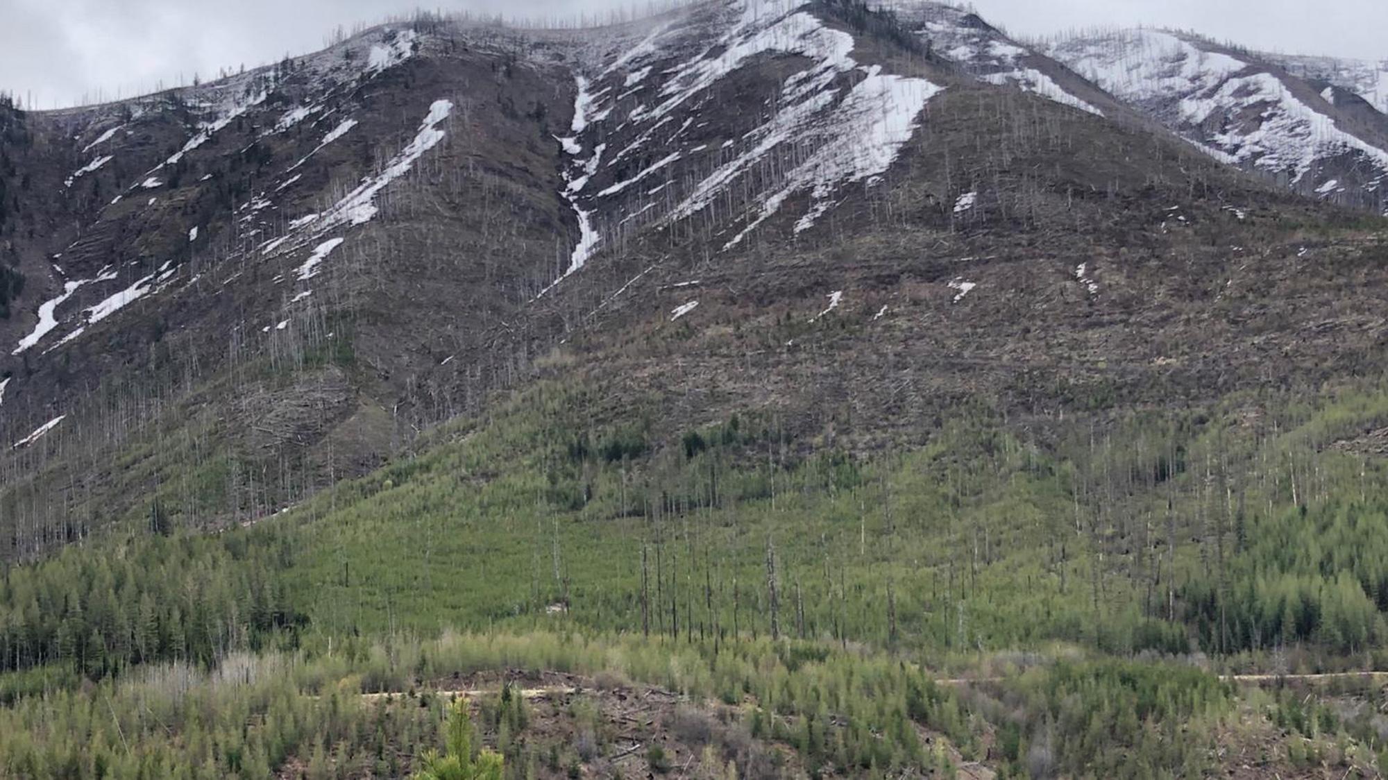
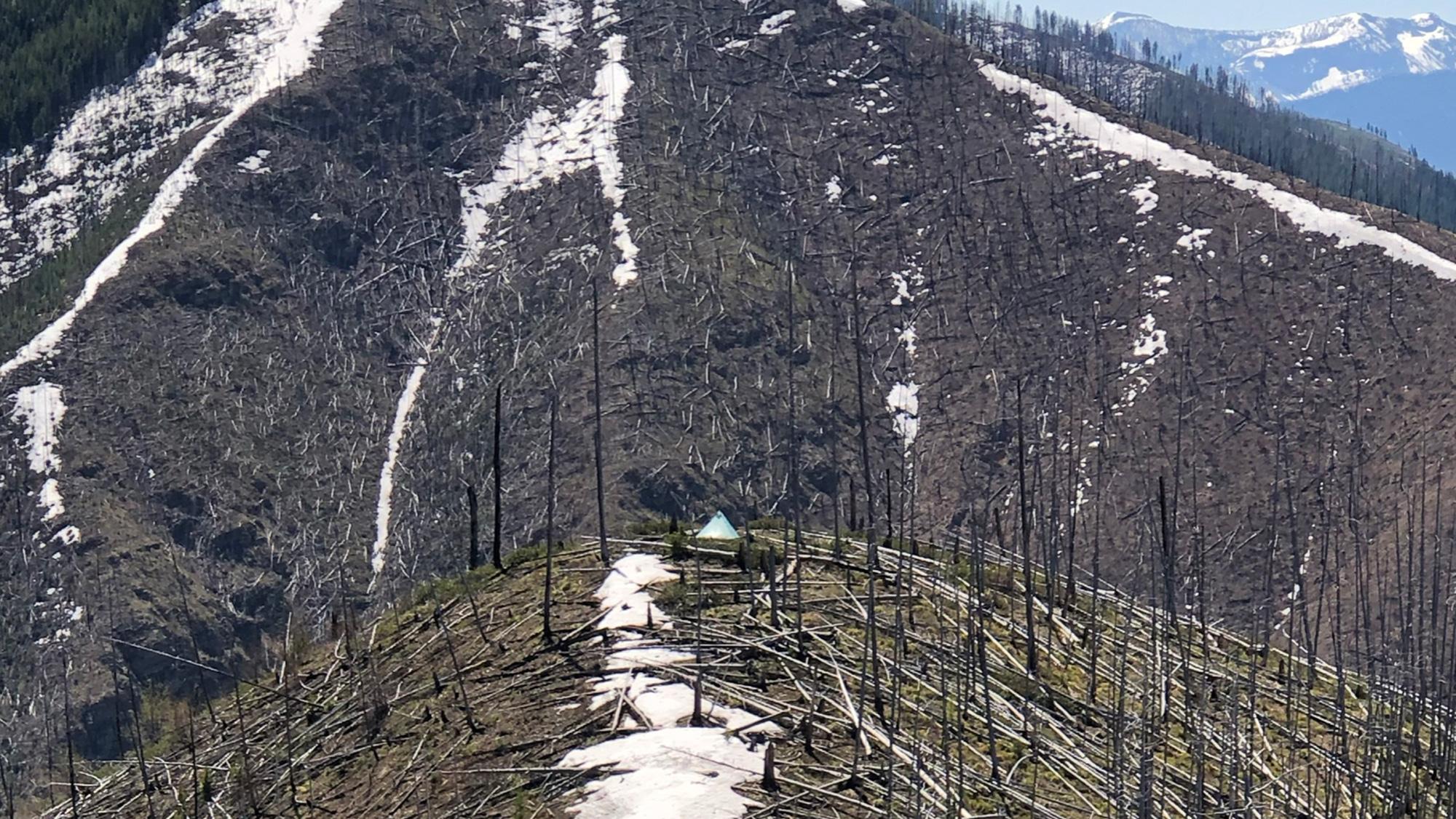
Identifying that south slope snow line for the time you want to hunt is important.
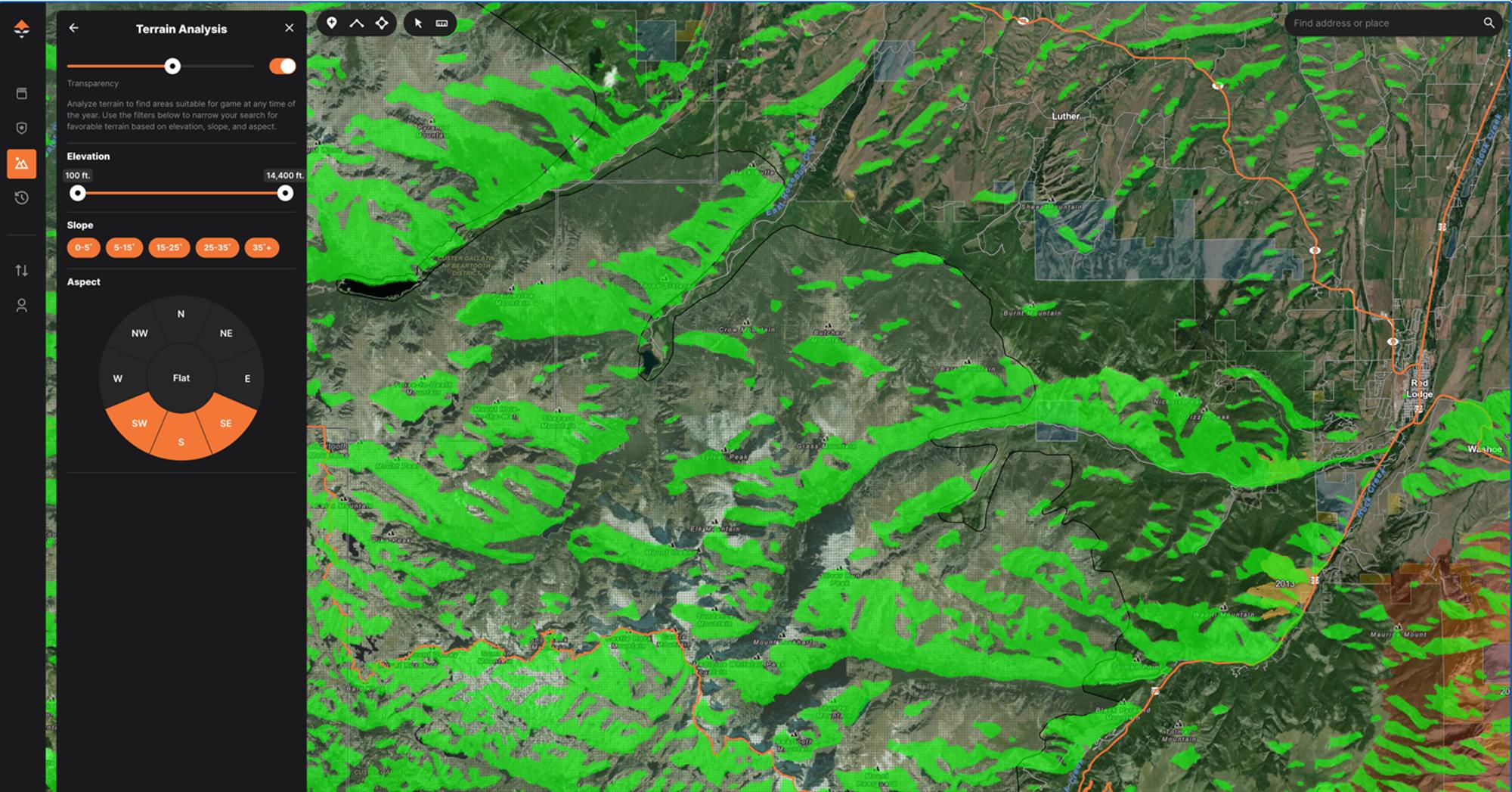
This setting highlights all elevations, all slope degrees, and only southeast, southwest, and south-facing slopes
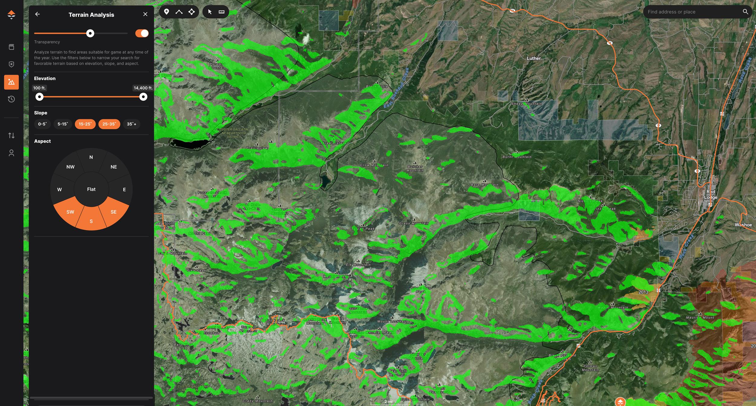
This setting further isolates terrain and shows elevations only at 15 to 35-degree slopes and only southeast, southwest, and south-facing slopes.
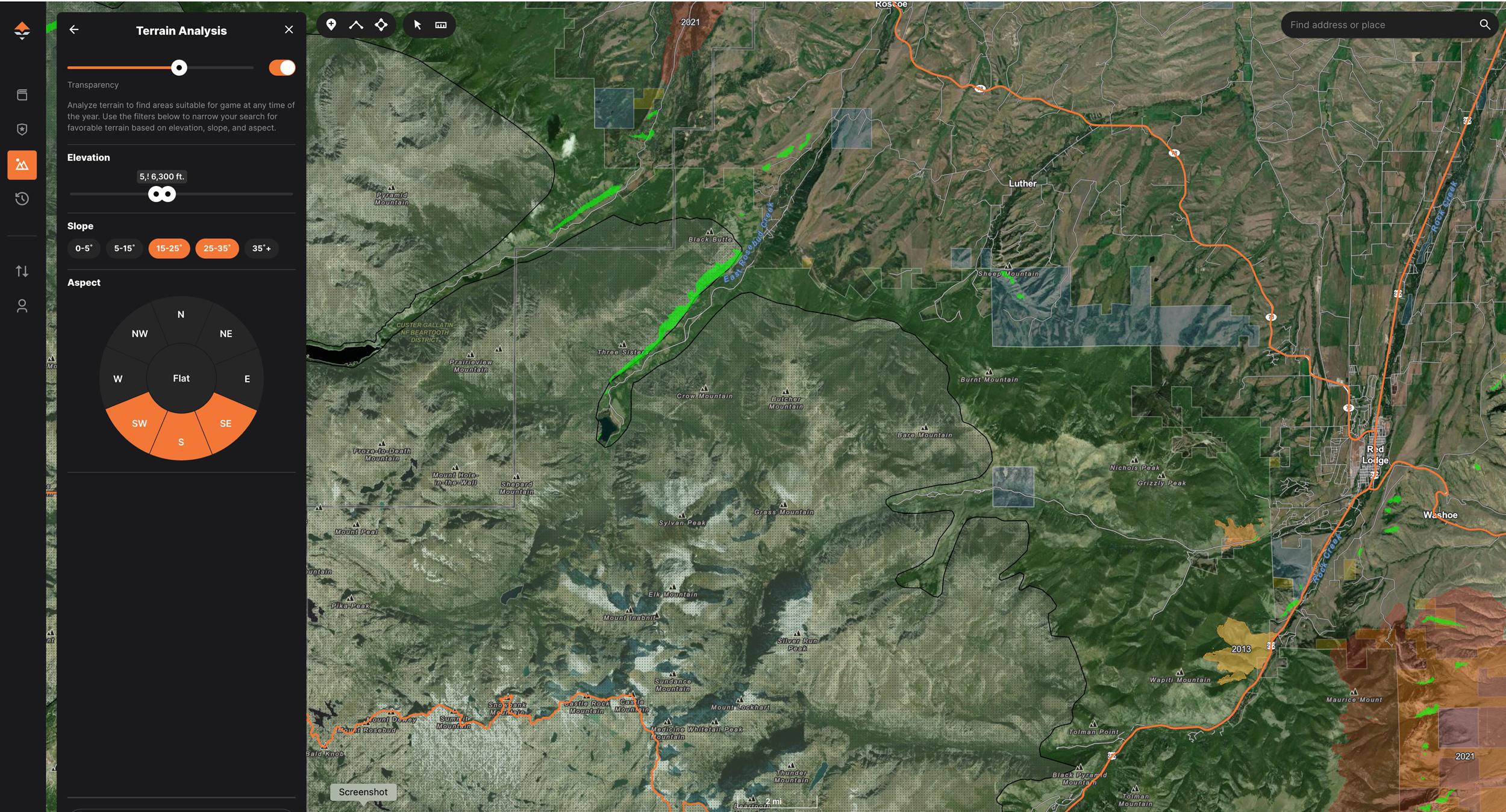
Further narrowing down terrain analysis to highlight areas to bear hunt
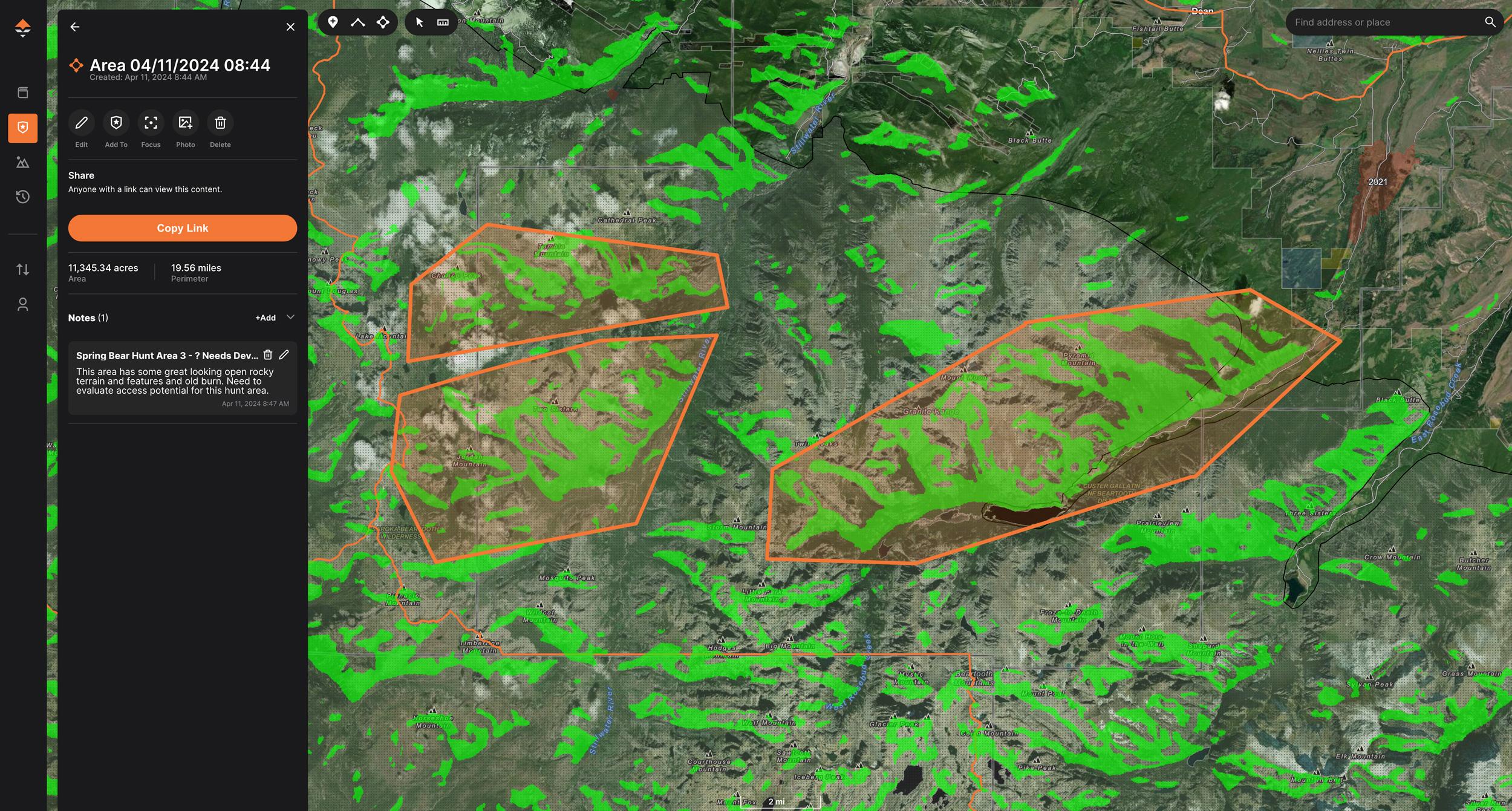
Creating areas and polygons around bear hunting hotspots
Spring bear hunting has surged in popularity among western hunters in recent years for good reason. Chasing spring bears offers the adrenaline-filled remote backcountry adventure type of hunts I crave. Over the past decade, my spring bear pursuits have risen on my hunting priority list, becoming one of my most anticipated seasons. In most years, I devote as much time to chasing spring bears as I do to elk and deer.
Yet, spring bear hunting presents some complexities. It comes with a unique set of e-scouting and hunt planning dynamics, particularly in states that receive high volumes of snowfall like Montana, Idaho and Wyoming.
Fortunately, our team has had consistent success chasing spring bears. A lot of this success directly relates to the identification of specific zones and terrain types during the hunt planning and e-scouting work.
As the spring snowmelt progresses, bears emerge from their dens, chase the snowline and prioritize the new growth of high-energy food sources. Southern-facing open slopes tend to green up faster and are prime focus areas for us. However, they're just one key element of the success equation.
Bears ascend to higher elevations as the spring snow melts, trailing the band of new green vegetation growth just below the snowline. Black bears in the snowy mountain regions are remarkably adaptable, and hunters must adapt their hunt planning and e-scouting work accordingly. The key to success is to track the “green up.” The question is how exactly do we pinpoint these zones?
The crucial first step is to identify the elevation of the south slope snow line during the time period you plan to hunt. This involves using historical snow research data and tools to make some solid predictions. It is vital to confirm and verify these predictions with real-time or recent data as you get closer to the hunt date. The objective is to pinpoint the snow line elevation, estimate snow depth and, finally, monitor the melting trends before the hunt.
The evaluation process hinges on the integration of various technology tools. Whether through podcasts or presentations, I consistently emphasize the importance of using the right tool for the right job and the advantages of having multiple tools in your hunt planning toolbox.
I produced and published an extensive two-part webinar, “Using Terrain, Elevation and Snow Analysis To Find Spring Bears.” This webinar walks you through the snow line evaluation process and the tools to help you get the job done. The webinar is currently available as part of my Treeline Academy E-Scouting Elk Course.
The GOHUNT Terrain Analysis Tool is indispensable for spring bear hunt planning. Once I know the approximate snow line elevation in my hunt area for my hunt time frame, I break out the GOHUNT Terrain Analysis Tool. This single tool allows you to isolate potential hunt areas based on slope orientation, steepness and user-defined elevation zones.
Slope orientation — whether north, south, east or west-facing — plays a crucial role in our hunting strategy. While a topographic map offers a basic idea of slope orientation, finer details, trends and clusters are often overlooked. We typically want to target areas with the highest concentration of southern-facing slopes or territory offering large, expansive south-slope views. For instance, use the settings outlined below in the Terrain Analysis Tool to specifically highlight southern-facing slopes.
Spring bears are drawn to steep, rocky, open terrain on southern-facing slopes. Utilizing the Terrain Analysis Tool, we further adjust the settings to include southern-facing slopes with steeper slopes or pitches. We generally find ourselves looking at slopes in the 15 to 35-degree range. The image below demonstrates how to highlight all southern-facing slopes within this angle range.
The last factor is isolating the critical elevation zone. We tend to prefer an elevation zone that is 750’ to 1,500’ in elevation below an “actively” melting snowline. We spend the most time in this zone, and this is where we usually find the most mature bears on the mountain.
Let’s consider this scenario: The image below mirrors the two previous ones. If our research shows that the south-facing snow line sits at 7,000’ in elevation during our planned hunt period, our optimal hunt area would fall within the 6,225’ to 5,550’ elevation range. As illustrated below, it quickly becomes apparent that the available territory within this elevation zone is very limited. This example shows how quickly and effortlessly you can pinpoint or exclude areas for spring bear potential.
After plugging in those three key factors, you can now begin to further evaluate the green-shaded zones. You can visually see how these potential hunt areas integrate with trailheads, recreational features and road networks. High-potential spring bear zones become obvious, characterized by clusters of shaded areas and expansive green patches that stand out prominently.
Now, the focus shifts to dissecting and evaluating these highlighted regions, scouring for terrain features that enhance our chances of encountering bears.
As you work through and identify potential hunt areas, utilize the GOHUNT area tool to drop labeled polygons around any locations that merit further evaluation. Personally, I prefer to assign specific-colored polygons for bears, elk and deer. Be sure to include any initial observations in the notes field. This detailed approach is almost never a waste of time and will significantly enhance your hunt planning process.
The GOHUNT Terrain Analysis tool stands as an indispensable resource in my arsenal when deciphering vast expanses of potential spring bear terrain. Its capability to dissect terrain and highlight key features is unparalleled.
It's important to note that the Terrain Analysis tool is exclusively available on the web platform version. Conducting this level of hunt planning and detailed evaluation work is best done before the hunt, during pre-hunt e-scouting work.
Incorporating the Terrain Analysis Tool into your spring bear hunt planning process will move the success needle.
Once you've accurately researched and pinned down snow levels, this tool becomes your guiding resource, allowing you to pin down prime spring bear hunt areas with precision and confidence. If you want to leverage the Terrain Analysis Tool for elk hunting, check out my other article on GOHUNT, entitled “Using GOHUNT's Terrain Analysis Tool to find more areas that hold elk.”
If you are interested in my Treeline Academy E-Scouting Elk Course, use the code GOHUNT for a 20% discount.
Also, be sure to check out Mark's OutdoorClass Course, "Next Level E-Scouting"
The ability to isolate only southern-facing slopes.
Zeroing in on prime slope angles sought by bears.
Identifying elevation zones corresponding to the current south slope snow line elevation.
High visibility slopes: We are always looking for high visibility areas, including large expanses of open, sparse, broken or patchy timber zones. Being able to see the bears is job one!
Transition/edge habitat: These are core areas where different habitat types meet, such as forest zones, logging operations and burned areas. Any type of edge habitat can provide diverse food sources and increased bear activity.
Avalanche chutes or slides: This ground disturbance clears vegetation, creating open space and exposing bare soil. These slide areas create vegetation diversity. The redistribution of nutrients contributes to soil fertility, promoting growth and, consequently, ideal places to find bears.
Bench areas: Bench areas (flatter topography spots) on these steeper slopes are some of the first locations to see new spring growth. Bench areas are especially attractive when they have some kind of small drainage running to them.
Water sources: Springs, seeps, drainages and creeks are essential for spring bears, especially during the spring when they're replenishing energy after hibernation.
Ground disturbing events: Ground disturbing events like burns and logging areas can generate fantastic new growth.
Glassing locations: Glassing is the name of the game when it comes to spring bears. We want to locate areas in which we can put our eyes on the most country that meets these terrain features.