


All images sourced from GOHUNT Maps

We're now through the dog days of May and although the current weather patterns just don't want to let go of winter, summertime scouting is just around the corner. Draw results are slowly starting to trickle out and the bulk of results will be hitting the front page within the next month. I myself am currently holding a mule deer tag for the 2022 fall season and I have at least one scouting trip planned at the end of July and if I play my cards right, I might get in a second one. Until that time comes, I’ll be buried in my GOHUNT Maps researching my unit, in order to maximize my time spent in the field. As an Insider and an Explorer member, you have access to GOHUNT Maps and all of its features. For this article, I’m going to run through some of the features that I use when I’m e-scouting a new unit for mule deer.
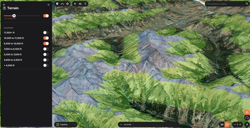
Once I get focused on the unit I’m hunting, a great place that I like to start is by filtering the different elevations. I do so by using the Terrain Tool layer, this lets you select the different elevation bands that you are looking for. So whether you wish to hunt high, or low, you can see which parts of the unit fall within that specific range. Now, mule deer can be found through a wide range of elevation bands regardless of what season it is. However, for this example, let’s think early season and a backpack style of hunt. Being early season, if they haven’t received pressure and they still have the essentials (water and feed), then I’d definitely start high. The higher, the better. Learn more about the elevation layers here.
As you can see, I’ve selected 8,500 to 10,000 feet (green) and 10,000 to 11,500 feet (blue). There’s obviously no shortage of high elevation in this unit and based on the topography, it’s telling me to really focus on that 10,000 ft. split. There’s plenty of water above it, there’s good cover and if it’s got the feed, then it’s a win. I personally like this tool because it allows me to look at the imagery and elevation, without having to toggle back and forth with a topo. With the elevation figured out, now you’re going to want to see how any of this is accessible.
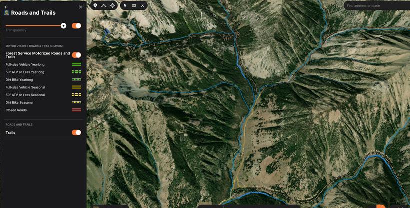
When I look at accessing an area, I not only look at how I would access it, but I try to think of how others would access it as well. By thinking of what other hunters might do, not only does that help me see the harder-to-reach areas, but it also helps me focus on areas that animals might get pushed to. For starters, I’m going to be looking for roadless areas and trailheads. What I don’t want is an area with only one trail in and one trail out, unless I have plenty of options to ditch the trail in order to get away from any traffic. Bottom line is, you want to have multiple options from one trailhead. If you only have one option, that’s a lot of eggs to put into one basket and you might find yourself packing back out to the truck. Using GOHUNT Maps, you can see all roads and trails available in your area.
You will be able to see where the roads stop, the trails start, and the difficulty of reaching different areas. My primary focus is finding basins where I most likely won’t see any other humans. That comes with years of trial and error though. If it’s a heavily populated unit, I like to look for that happy medium when it comes to the distance of packing in. I want to get beyond the foot soldiers, but not as far back as the horseback crowd. Most times that area in between is where animals tend to get pushed too. When the time comes to hunt, I would also keep your eyes out for places where everyone is packing in beyond a certain distance. If nobody is paying attention to what's within the first couple miles of the trailhead, it might be worth taking a look at. I’ve personally found bucks in places where people were doing just that.
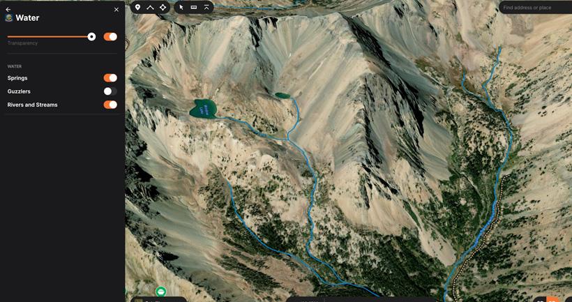
The distance that mule deer will travel to get water varies quite a bit between your dry and wet climates. I’ve hunted areas where they’ve routinely traveled up to 4+ miles to get water. Luckily, I don’t think that will be an issue for this particular area. Based on the terrain search, I already know that there are some water sources up high. Now I want to pair that with the trails that get me in the ballpark, but off the beaten path. Mule deer will need to feed as well, but in most cases, if the water is there, the feed will follow. The biggest key is to find these sources away from the main trail systems. With mule deer, everything they do in life, they prefer to do it without being bothered. Using GOHUNT Maps, I can go back to those basins above the 10,000 ft line and search out what water sources are there.
I can see that there are a couple of high basin lakes, an offset spring just below, and a creek running down the main drainage. The initial look tells me that there should be year-round water up high. The actual scouting trips that I take in the upcoming months is when I will be able to confirm all of this. If there is enough feed up near these water sources, those bucks will have absolutely no reason to come off the top.
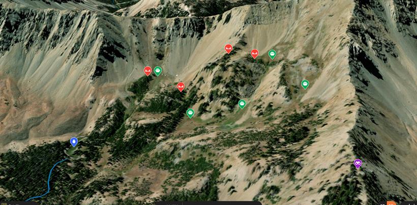
When it comes to isolation, big bucks don’t like to be bothered. So you want to make sure the basins you're looking for have plenty of good bedding areas and escape routes. They are always going to have a way out, remember that. Typically, before they’ve been pressured, they have a tendency to be a little loose when it comes to their decisions on where to bed. You might find them bedded up in a wide-open shale slide, tucked in a thicket of trees or perched up on a cliff soaking up the morning sun. To them, it depends on how comfortable they are with that basin and where their escape routes are. I’ve put together a little example below.
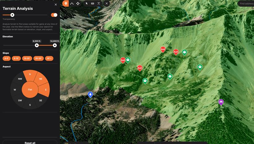
What I’ve picked out in this basin is the main water source, bedding areas, feeding areas and a good vantage point to see it all. With the Terrain Analysis Tool, I can set the elevation, slope, and aspect to get an accurate visual of the basin. Out of those three, I’m primarily focused on the elevation and the slope aspect, or what direction the slope is facing. I want early morning sun and afternoon shade (as pictured below).
When it comes to where to set camp, I usually like to set my camp as high as I can. I typically prefer to hunt from the top down. But the biggest challenge with camp is water. One thing you definitely don’t want to do is camp on the same water source those bucks are using. Hard to believe, but I’ve seen people do that before. A lot of times, if there is very minimal water up high, there will at least be a strong source down in the main drainage. If that's the case, it looks like you’ll be camping lower than you want and putting on a good climb each morning. The key is not to take away the source from which they are using. If there are a lot of water sources up top, then set camp a good distance off of water and you’re all set. Just remember, minimal impact will increase your chances. When you physically go and scout the area, that’s a great time to find all of your water sources. Hopefully, find which ones the bucks are using and possibly find ones that you can use for camp water.
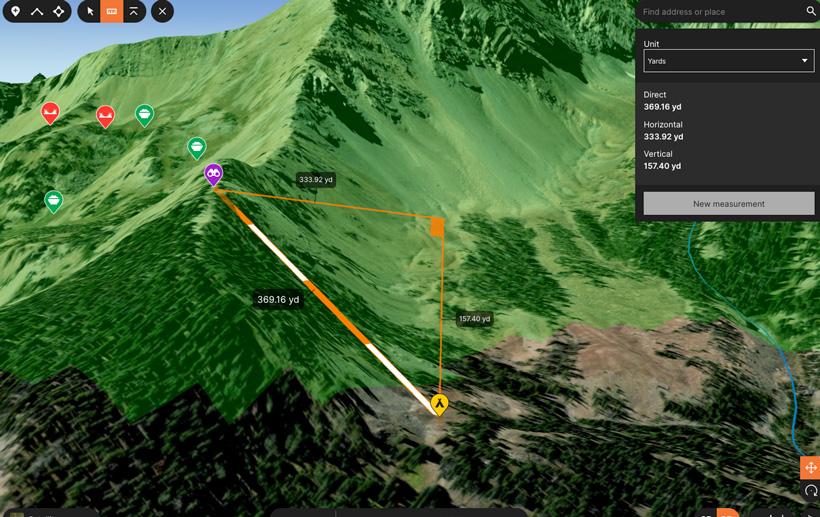
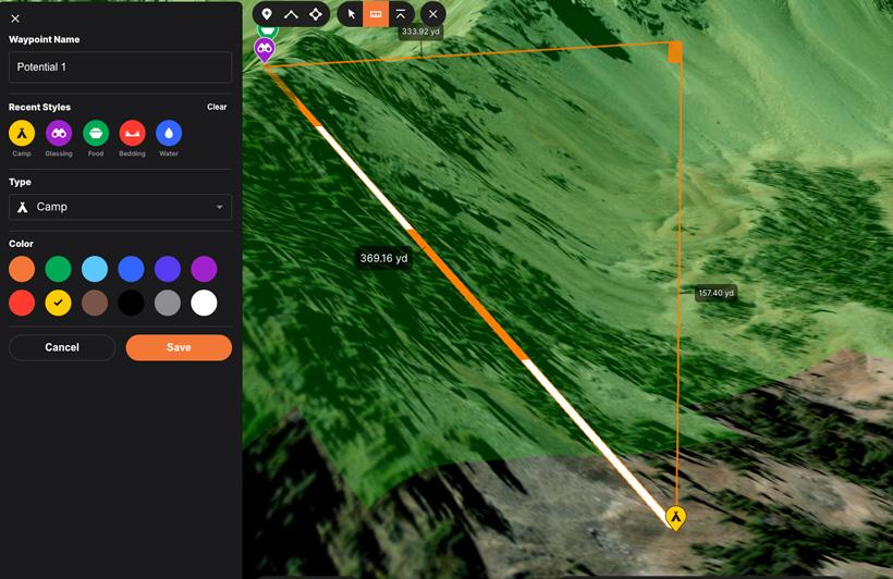
Pictured above, is an example of setting camp away from the main basin I wish to hunt. Camp is set in a benched off area that’s roughly 370 yards from where I would like to glass from. There could be the chance of having water within the vicinity based on imagery, but if not, there’s water down in the creek. This camp would be pretty secluded and not up in the golden regions of the basin. Before taking my actual scouting trip, I would scan the area and mark at least three of these potential camp spots, in hope one will do just fine.
In the end, this basin looked pretty good based on the key things that I look for. I’ll be sure to save all of my waypoints in a hunt folder (trailheads, campsites, glassing knobs, etc.) and mark it as a “potential one.” So when I go on my trip, I pull up my hunt folder and all my waypoints are inside and ready for me.
I like to make sure that I have plenty of options when I go on a hunt, so I will use the same strategies on e-scouting and find a potential two, three and maybe a four. Save all of those in different hunt folders and you’re ready to go for each spot. The actual “boots on the ground” scouting trip will be the final decision maker for my top two places. E-scouting with GOHUNT Maps will help maximize your time in the field while you are scouting. With the knowledge you gain ahead of time, you might have the opportunity to hit multiple places in one trip. Which in turn cuts down the number of trips you make. But the biggest thing is, it can help you get all the logistical issues worked out beforehand, that way you are spending more time finding and patterning those big bucks. Good luck to all in your 2022 season.