


As winter recedes and the snow begins to melt, the anticipation builds for spring bear hunters. There is nothing quite like the excitement of pursuing these elusive creatures through the rugged terrain of the West.
Spring bear hunting is a high priority season for our team. We spend nearly as much time chasing spring bears as we do most other western big game. Our goal each year is to have two to three bear tags in our pocket with hunt plans in place to chase bears for more than 30 days, spanning the entirety of the season.
We primarily hunt high snowpack states like Idaho, Montana and Wyoming with a few others thrown in from time to time. This means a comprehensive understanding of snow levels is at the top of our spring bear hunt planning list.
Understanding snow conditions is critical to our success and we spend a lot of time analyzing and breaking down the historical and current snow cover and snow depth while evaluating the melting progress. Dialing in the snow line for our specific hunt areas and hunt dates is a priority. The next step is to match that snow line up with specific elevation zones or bands. Once the elevation zone is pinned down, we start developing hunt areas that are within those specific elevation ranges. Finally, we work to identify the bear finding features within that zone.
We primarily use spot and stalk tactics in the spring, but the principles covered in this article are easily adaptable to baiting and calling tactics.
These five initial spring bear tactics are a big part of our consistent success and can help you move the needle as well.
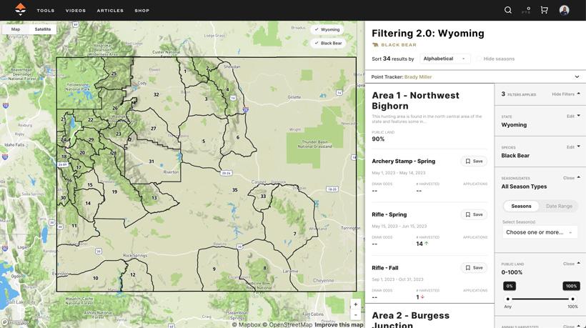
GOHUNT Insider has always been my go-to resource for western big game and spring bear hunting is no exception. To narrow down my options, I use Filtering to identify the units that interest me. This tool displays recent bear harvests in graph format, allowing for quick and easy trend analysis. I’ve been an Insider member for years and can attest to the value of this tool for planning all my western hunts. Learn more about using Filtering 2.0 to find spring bear hunts here.
The GOHUNT platform recently introduced a new Hunt Planner feature that enables users to save units to a Hunt Folder for easy side-by-side comparison.
GOHUNT Insider is an excellent resource, but I do like to dig deeper into bear harvest statistics. I prefer to examine historical averages for at least three years and I find that a spreadsheet format is the best way to sort, rank and pour over the data.
The Treeline Academy Map Toolkit Bundle features a new spring bear data layer that includes direct links to bear harvest statistics for several western states, including Idaho, Washington, Oregon, Montana, Utah and Wyoming.
Analyzing this data can reveal units with stable and significant bear populations. However, many states publish harvest reports in PDF format. A PDF is great for simple viewing, but I like to go further with my data analysis. I prefer to sort and prioritize my data and this is best done if the data is in a spreadsheet format. Fortunately, Adobe offers a free online tool to convert PDF reports into spreadsheet format, which makes it easier to sort and prioritize the data. Once converted, these reports can then be viewed, edited and sorted in Excel and Numbers. Use this link to access this quick conversion tool.
Remember: when analyzing harvest numbers, it's not always about finding the highest numbers. Instead, we want to identify units with significant and stable bear populations. This level of research helps us eliminate zones or units that might not be as productive for our hunting goals.
Spring bears will always follow the food source. This is especially true in the snowpack states where we hunt. As bears emerge from hibernation, they begin to track the spring green-up as it moves up in elevation following the melting snow line. Predicting this elevation migration can be a real challenge. One of the very first questions you need to ask yourself is when you are going to start chasing bears. There are two main approaches to scheduling and planning your spring bear hunt.
When you start planning a spring bear hunt, one of the first and, perhaps, most important factors to consider is the snow cover, depth and melting progress. Without a solid understanding of these concepts, it’s incredibly difficult to identify and develop a successful hunt area. This is especially true in states that experience heavy snow accumulation, such as Montana, Idaho and Wyoming.
The earlier in the spring season, the more critical this next level analysis is. You might find a great looking area with steep rocky terrain, perfect slope orientation, sparse timber and visible open areas only to find out the snow is 3’ deep until June 15.
To gain valuable insights into snow cover, depth and melting progress, you need access to both current and historical snow data. The Treeline Academy Map Toolkit Bundle provides a set of files that can be directly installed into Google Earth Pro. This single file download gives you over a dozen hunt planning data layers and they come with a complete set of historical and current snow data layers. These custom layers show snow cover, snow depth and melting progress for key season date intervals such as April 15, May 1, May 15, June 1 and June 15. The data set contains three years of data for each of those dates and can be easily toggled on and off, allowing you to span your research through the entire season.
The snow cover layer shows the snow footprint for the entire U.S. This all white layer helps you to quickly zero in on the snow lines and elevation ranges in potential hunt areas for the specific historical hunt dates. Knowing where the snow line has been over the past several years on specific dates can be a critical piece of the puzzle when it comes to finding spring bears. As you approach your hunt date, you can switch over to using the latest snow level tool to confirm or fine-tune your historical predictions.
The snow depth layer goes further and, when activated, provides you with estimates of snow depth throughout the area. The legend for snow depth is included at the top of the window. Snow depth analysis can be an important tool when comparing specific historical dates from year to year.
The snow melt layer is a great resource for identifying the melting stages of the snow line. This can give you an indication of the water runoff and ground moisture levels. These conditions directly correspond with the green new growth that spring bears are so keyed in on. We like to target and hunt areas with actively melting snow lines, which are indicated by the yellow and red zones along the snow edge.
As I mentioned, the Toolkits also give you access to the current or latest snow data conditions. The National Operational Hydrologic Remote Sensing Center (NOHRSC) data sets are great tools for breaking down the potential snow levels and melting progress in your hunt areas.
GOHUNT has two fantastic spring bear tools! If you are not using these tools, you are leaving a lot on the table when it comes to finding and developing spring bear hunt areas.
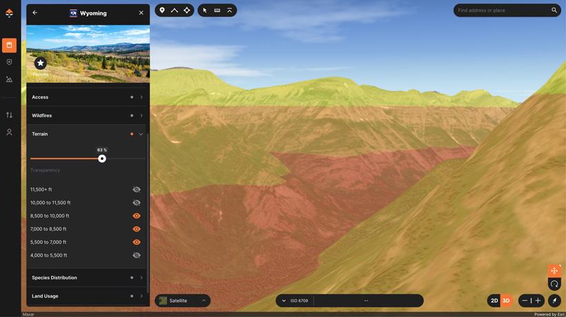
Now that you know where the snow line is and what the melt is doing, the next step is to zero in on that specific elevation band or range. The GOHUNT Map platform has an elevation band tool that can help you do just that. The elevation bands are colorized layers that are separated into 1,500’ sections.
The process is simple – turn on the layer, set the transparency, activate the range(s) you are looking for and presto! All the areas in that specific elevation zone are color shaded. This tool can provide you with a big-picture overview that visibly isolates the selected elevation bands in the entire hunt area or even the state.
Activating these elevation bands will clearly show you where you should be looking and, more importantly, where you should not be looking regarding your particular hunt date.
Once you understand the reason and benefits of the elevation band tool, using it is a piece of cake. It will definitely be an "aha" moment.
The GOHUNT Maps Terrain Analysis tool is only available on the GOHUNT web-based platform. That is fine with me because I always recommend using web-based platforms for all pre-hunt e-scouting and hunt planning. Using these tools side by side is where using a dual-monitor e-scouting setup really shines.
In states with high snowpack, the snow generally melts first on the south-facing slopes since those slopes see the most sun in the spring. This combination generates the green salad zone, making them prime focus areas for spring bears.
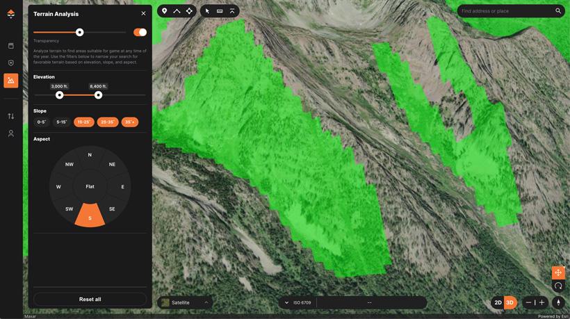
If you have solid map reading skills, you can get a pretty good idea of slope orientation by looking at detailed topographic maps; however, the GOHUNT Terrain Analysis Tool makes the process incredibly easy and can help you identify the exact slopes you're looking for. You might be surprised by how many slopes you overlook using only the topography map view.
Additionally, this tool can reveal clusters of south-facing slopes in certain areas. When you see these clusters, you might want to consider further investigation.
The GOHUNT Terrain Analysis process is simple and self-explanatory:
As I mentioned earlier, the elevation band tool shows you ranges of 1,500’. Perhaps you want to define the elevation range more exactly. You can use this Terrain Analysis Tool to select custom elevation ranges. Simply select all slope angles, select all slope orientations and then use the slider to dial in the exact elevation range. It is that easy — now you can set the elevation to any custom range you need.
These advanced tools from GOHUNT are literally bear killers!
It's important to avoid being one-dimensional during the hunt planning process. Selecting and using the right tool for the job is a principle I’m always preaching about. You can elevate your bear hunting game by learning how to use and incorporate multiple tools into your hunt planning arsenal. Effectively using the right tools to evaluate snow cover, snow depth, snow melt, elevation bands and slope analysis will help you take your bear hunting pursuits to the next level.
Good luck this season!
Defined hunt date: If you have a specific hunt date in mind, (maybe you're planning a hunt for next year right now), and thinking about hunting starting on April 15, you'll need to identify spring bear hunt areas that have suitable snow cover, depth and melting conditions during that exact time range.
Flexible hunt date: With a flexible hunt date, you can focus on finding a prime spring bear hunt area and then use the Treeline snow analysis tools to determine the optimal time to chase bears in that area. If you have flexibility, this approach allows for greater hunt area adaptability.
Activate/turn on the Terrain Analysis Layer.
Set the transparency level.
Select the elevation ranges.
Select specific slope steepness or select all of them.
Now simply select the slope orientation you want. S, SE, and SW will show you all the slopes that you might consider exploring.