




I don't care if you're hunting the desert floor of Arizona or the 13,000’ high country of Colorado: only a small percentage of any given area will hold big mature mule deer. In my book, Hunting Big Mule Deer, I dedicated an entire chapter to learning how to recognize big buck country. You must hone your ability to size up buck country quickly or you'll waste countless days and boot leather hunting country that likely doesn't attract big deer.
Google Earth is a great tool that can help you recognize buck country and plan your hunts. Once you know what you're looking for, a few minutes on Google Earth will show you more country than you'll be able to hunt in a lifetime, let alone a season. You can also check out these other articles on utilizing Google Earth for scouting and hunting.
Below are some Google Earth images of deer country that occurs in most of the western states from desert to high country where big mule deer are found. I've given it my best shot in predicting where bucks will be during particular seasons and also share how I might personally hunt each area. I hope this information can help you on your next mule deer hunt.
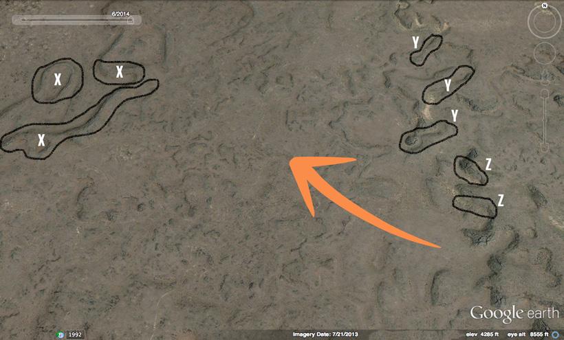
This is a typical desert mule deer habitat with limited water. I'd start by trying to locate the water and deer tracks. Assuming there is water near each of the circled "bucky" areas, I'd then hunt these places. It could take me five days to hunt an area like this, and even longer if I'm finding bucks or big tracks and there's not a lot of pressure to move the deer.
Orange arrow
The orange arrow is the wind direction. The prevailing wind often determines which direction you'll approach areas from. Bucks can smell you at roughly a distance of half of a mile and under; however, it's often the terrain-driven thermals that will dictate your terminal approach. Monitor and obey the wind at all times.
Area X
The three spots marked with an "X" show possible feeding areas that are next to bedding areas with some north facing aspect. I'd either find a way to glass these from a long distance or, if that wasn't possible, still hunt these mesas slowly at first and last light.
Area Y
On these mesas marked with a "Y," bucks will feed on top and bed on the sides that typically have some north facing aspect; it all depends on the time of year and weather.
Area Z
These areas marked with a "Z" show classic bedding areas. These are steep, rocky places with brush and have some northern aspects.
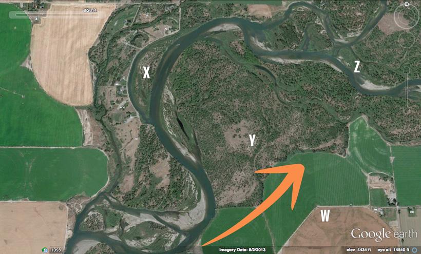
This is riverbottom/agriculture/BLM country. Bucks can get old and big in places like this for three reasons: 1) limited access due to checkerboard private/public; 2) highly nutritious feed in the fields; 3) the simple fact that many hunters ignore these places because they think all the big bucks live in the mountains. Even if I can't get access to the private land, I'd still scout this area. Private agriculture tends to have little cover to hide deer during daylight hours and is usually adjacent to public ground with cover, which means that bucks are very likely to spend daylight hours where I can hunt them.
Orange arrow
The orange arrow is the typical prevailing wind.
W area
The area marked with a "W" is a place that I'd glass the fields from the public road the first and last 30 minutes of daylight for bucks. Big mule deer bucks won't venture into the fields very far so watch the edges near cover.
X area
The area marked with an "X" shows an island that might never see a hunter. I wouldn't worry a bit about the houses located across the channel (until I'm ready to shoot). I've killed several big bucks on public ground and within sight of houses. Big bucks have an uncanny ability to go where no one else goes even if it's only a few hundred yards from civilization.
Y area
The area marked with a "Y" is a BLM section that bucks will use for bedding cover. You may have to access it by boat. I'd place trail cameras on any trails near the fields. I'd look for tracks and buck beds. I'd only go in and still hunt it with the wind in my favor and move carefully.
Z area
The area marked with a "Z" is more remote country bucks might be using. I'd check the sandbar areas for big buck tracks.
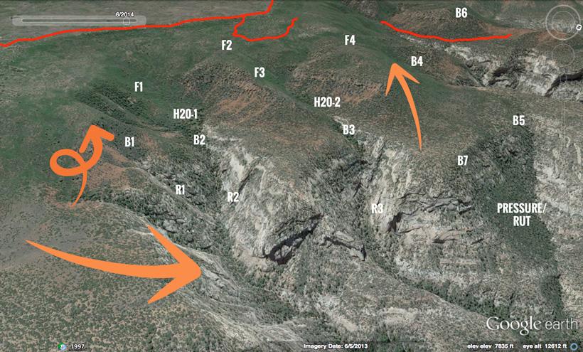
This is mid-elevation mesa type country. Although this is a photo from Utah, you can find this country in Arizona, Nevada, New Mexico and southern Idaho. Bucks love mesas as they feature varied terrain with multiple escape routes. Mesas are hard to glass and, consequently, can hold some old bucks as long as road densities and hunter numbers aren't too high.
Orange arrows
The horizontal orange arrow showcases prevailing wind, the curly and uphill arrow are daytime thermals.
Red lines
The red lines show the road access on top. Hike at least a half mile from roads unless there are very few licenses.
B1 to B7
These areas show possible bedding areas. Notice they're just off the edge of the mesas in the cover. Try to glass these areas from above. Still hunt slowly and glass every angle as you approach these spots. Your shot maybe less than 100 yards due to thick brush so be ready. If I'd scouted a big buck in this area, I'd only hunt here the entire season, nowhere else.
F1 to F4
These are feed areas with some northeast aspect, which in dry country holds moisture and feed. Hunt these during the August/September season by glassing at first and last light. By October, bucks will have mostly vacated this open country.
H20-1 and H20-2
I'd have trails cameras on these two water holes by late June. It's the only water within a few miles so those cameras will eventually show you the bucks.
R1 to R3
The country below these mesas is too rocky for bucks.
Pressure/rut
Bucks might end up down in the lower country with increased hunting pressure or the rut. Plenty of feed and cover can hold bucks here.
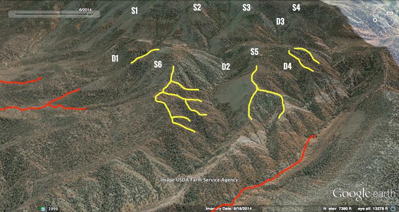
This is some mid elevation 8,000’ to 10,000’ Colorado pinyon-pine and juniper country. It's thick, steep, and hard to glass; therefore, it will hold some big bucks. It has some roads that are roughly a mile between each other, which is still enough to grow big deer unless hunter numbers are high.
It could take me up to a week to hunt this entire mountain correctly. Although I might not kill a buck, I know I'd be hunting where they live and a real giant can show up in country like this.
Yellow lines
The yellow lines are ridgetops above brushy draws that I'd hunt if the weather was mild and hunting pressure wasn't too high. I'd hunt with the wind in my face and glass very carefully any opening I came across. I'd also watch closely for tracks and ambush points.
Red lines
The red lines are roads. Bucks might be near these on a third or fourth season hunt in Colorado if there were very low tag numbers. Otherwise, I'd hunt away from these roads. The road on the right side of the photo is one I might use to access the country to the north and east.
D1 to D4
These points show draws where bucks will retreat to when hunting pressure increases or when bucks experience high wind and blizzard conditions. With those conditions, still hunt the draws with the wind in your favor. Hunt up one side of the draw so you can glass the openings on the other side.
S1 to S6
These are areas where bucks could be found in the summer scouting season as long as water is located within a mile of these areas. If I had an early season archery or muzzleloader tag, I'd hunt near these "S" areas, glassing at first and last light.
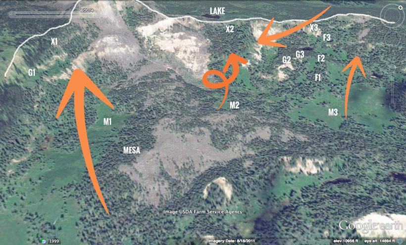
This is typical Colorado aspen/oak/pinyon-pine and juniper country where some of the biggest bucks in the west live. The top of the ridge marked by the white line is around 11,000’ in elevation.
Orange arrows
The arrow starting in the upper right of the photo showcases the prevailing winds. The other orange arrows are daytime thermals.
The daytime thermals will mix with prevailing winds to create finicky, swirling winds in certain areas. This creates a problem for hunters, but bucks love these places.
M1 area
You might catch bucks at the first and last few minutes of light in this meadow. Glassing, still hunting, and ambush hunting area all great tactics for this location.
M2 area
This meadow/bench might be a good spot to look over at first and last light.
M3 area
This meadow is just too big and flat to hold bucks once the season opens.
Mesa
This mesa, with a feed area to the west, has enough cover to hide bucks. Still hunt it and watch for big tracks.
G1 area
The bench near G1 could hold some bucks. I might glass the area from above.
G2, G3, F1 and F2
This is some of my favorite country in this photo. This spot has plenty of varied terrain, feed, cover, and even some vantage points near G2 and G3.
X1 to X3
While most hunters would head for the tops, don't expect the bucks to be there in any numbers. It's too rocky with low amounts of feed. X1 to X3 mark the places up high where I'd expect to find some bucks, but only before the snow and rut hit. Bucks living in this country would be extremely hard to glass and most hunters would give up quickly. A patient hunter/ambush hunter should hunt these areas with the wind in their face along game trails, saddles, and bedding areas.
Lake
While this lake off in the distance has buck country all around it, I'd expect plenty of hikers and hunters there, too.
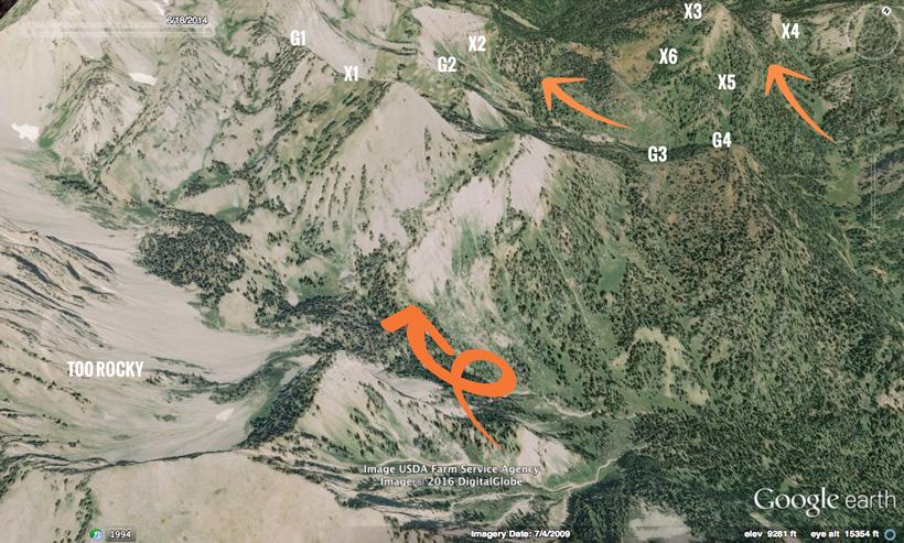
This type of terrain is typical of Wyoming, but I've hunted similar country in Colorado, Idaho, and Montana. While most hunters think of archery and early rifle hunting in places like this, I find that big snow in early October can be the best hunting. No matter when you hunt, remember that bucks in country like this rarely encounter humans and will disappear much quicker than their lower country compadres. Hunt carefully, don't skyline yourself, and always obey the wind!
Prevailing wind
While the prevailing wind will come from the southwest, it will likely affect the high ridgetops the most. I'm more concerned with daytime thermals in country like this. Obey the wind!
Too rocky
This country is too rocky and very low feed for big bucks. You'll find more mountain goat in this type of terrain, but not many bucks.
X1
This is a really good hillside in the early season before bucks are pressured. I'd backpack in with water up to G1 and glass the X1 area for a morning, evening, and morning session. Bucks will likely bed in those timbered strips.
X2
This is a feed area adjacent to a bedding area. In the early season, I'd glass from G2 for a morning, evening, morning session before I'd move on. If I spotted a big buck feeding at the timber's edge and he got away, I'd set an ambush in the afternoon downwind from X2 and hope to catch him at dark entering the open country.
X3 to X6
These areas are my favorite place in this entire shot. It's a big mountain with semi-timbered basins, benches, avalanche chutes, and some semi-open ridges with great feed. The mountain can really only be glassed from long distances on the ridge from G3 to G4. I'd camp near there and glass the mountain for several days trying to narrow down where the bucks are. Once I had a good idea of the bucks in the area, I'd approach the areas with the wind in my favor and move in very quietly. Shots are likely to be less than 250 yards here. Although I may see other hunters, I don't think the bucks will leave the mountain as it has plenty of timber. If it snowed, I'd hunt all day looking for tracks and bucks staying out of the cover longer. I may hunt a mountain this size for a week, especially if I've seen a big buck there.
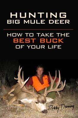
Robby Denning is author of Hunting Big Mule Deer: How to Take the Best Buck of Your Life and co-owner of the hardcore gear website, Rokslide.com. You can follow his mule deer blog below.